Exploring the Canal and Amador


Advertisement
Panama's flag
Central America Caribbean » Panama » Panamá » Panama City
February 24th 2007
Published: February 27th 2007
Edit Blog Post

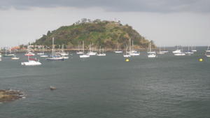
Man-made "tiny island"Man-made "tiny island"Man-made "tiny island"

Part of the Amador, where built up dirt had created a small island.
We decided to explore the Canal without really knowing where to go. Ended up making it to Amador...this is a small penisula of land that was created by the dirt and soil dredged up during the creation of the Canal. The long winding peninsula has several restaurants, a Smithsonian station, some residences (that we didn't see), and lots of natural beauty.

Good thing I didn't rely on Richard's interpretation of the maps we had and that he was reading...none helped much and we kind of fell into the area we were trying to get to by pure luck and chance! I am not sure why, but the majority of countries in Central American have most of their major roads without any street signs!

Advertisement


28th February 2007

shots
will be waiting for pics of "shots" - beach shots, tequila shots, etc. btw - hope u both got your shots before you left town
7th March 2007

The Maps
Good thing she didn't rely on my interpretation of the maps? Sheeit - as though if she were looking at the map (which she did from time to time when we stopped), everything would have gone just perfect, right? I can read a map as well as anyone, just that we didn't have good detailed Panama City maps, and you gotta have a lot of patience as a driver. R
7th March 2007

no shots...well sort of
The only shots we did prior to and during our departure were a couple of shots of rum :>). No need for shots in Panama unless traveling in the remote areas off to the east (which we didn't do this time).
7th March 2007

Maps....bad, bad, bad.
The maps were very bad...worse yet were the changing street names. The driver had a hard time reading tiny street sign names while also trying to interpret large overhead signs, avoid careening and speeding taxis and cars that ignored most signals and stop signs, and at the same time, listen to the map reader. :>). In the end though, we figured out the overall city layout, which will make the next trip a whole lot easier when driving around and through the city proper. A

Tot: 0.076s; Tpl: 0.01s; cc: 9; qc: 43; dbt: 0.0544s; 1; m:domysql w:travelblog (10.17.0.13); sld: 1; ; mem: 1.1mb