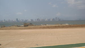
Pacific side of the Canal


Advertisement
Panama's flag
Central America Caribbean » Panama » Panamá » Panama Canal
February 24th 2007
Published: February 27th 2007
Edit Blog Post

Point off Amador looking NorthPoint off Amador looking NorthPoint off Amador looking North

We are at one of the three "island" points on Amador. We were not even sure which one...first, second or last. But nonetheless, we are looking north towards the Panama City skyline.
More pictures of the area around the Pacific opening of the Canal.

ADDED on Wednesday, March 7. 2007: I didn't add these photos until we got back since the internet bombed out when I had gotten to this point (from our hotel - Hotel Los Capitanes - in El Valle de Anton, Panama). Getting internet access where we could hook the digital camera directly to the public computer proved difficult. Getting internet access with my own laptop was also somewhat allusive.

Now that we are back -- to some unbelievably arctic surroundings! -- I will be adding all of our photos and a few comments, if needed. Richie will be adding his version of our travels as the mood strikes. All in all, we had a great time and would encourage everyone to consider a trip to this unique, paradisiacal, isthmus country! In fact, friends and family are invited along for our next visit.

anna


Additional photos below
Photos: 7, Displayed: 7


Advertisement

Some Amador Restuarants and ShopsSome Amador Restuarants and Shops
Some Amador Restuarants and Shops

This is from the same spot as the last photo, but turning around and looking at the restaurants and shops on this section of Amador.
International Pan-American Highway BridgeInternational Pan-American Highway Bridge
International Pan-American Highway Bridge

From the same spot in a different direction, we could see the "Puente de Las Americas," (Bridge of the Americas)which connects western Panama to eastern Panama. Another way to think about it is that this bridge connects the southern hemisphere with the northern.
Smithsonian Tropical Reseach InstituteSmithsonian Tropical Reseach Institute
Smithsonian Tropical Reseach Institute

This picture was taken from within a very small, but very cool, outdoor research park. One takes a circular stroll through the park, to view various flora, fauna and rock formations that exist in this part of the environment. We are still on Amador, looking towards the non-canal side this point, which would include small inlets and bays off the Pacific.
Far From "3rd World"Far From "3rd World"
Far From "3rd World"

Lots of sailboats making port on the non-canal side of Amador. Man-made island in the background.
Mi Ranchito - Restaurant Bar and GrillMi Ranchito - Restaurant Bar and Grill
Mi Ranchito - Restaurant Bar and Grill

A hotel and restaurant on Amador, just outside of the Smithsonian research park. We had a bit of lunch here. Panama City in the background and lots of LOUD PARTYING people at the far end of the pool. It seemed like a reunion of sorts and they sure were having fun! We were too tuckered by this point in the day to wander over and meet anyone.
Zoom on Panama CityZoom on Panama City
Zoom on Panama City

Same shot as the last, but zooming in to show how developed Panama City is...and many more skyscrapers than can be seen are under construction all along the Pacific coast. Possible future condo home site????


Tot: 0.081s; Tpl: 0.011s; cc: 10; qc: 48; dbt: 0.0481s; 1; m:domysql w:travelblog (10.17.0.13); sld: 1; ; mem: 1.1mb