Advertisement
Published: June 10th 2019
This morning, our bus left the Holiday Inn in Clayton, and headed towards the Atlantic Ocean on
Corridor Norte. While Roberto navigated our bus, Abdiel discussed Panama’s position on land preservation and environmental protection. He said that 42%!o(MISSING)f the land in Panama is protected by the government for green space allowing for water mitigation and natural flow to the canal. A portion of the same 42%!o(MISSING)f land is also used for parks where some of the protesting squatters live. He also informed us that Stanley Motta, who some may know from his calypso record label in Kingston, Jamaica, owns the Panamanian airline COPA (that some of us will use flying to Colombia). COPA makes up 14%!o(MISSING)f Panama’s GDP. Motta has become an extremely wealthy man and is very influential in Panamanian elections. Abdiel told us that it is
cheaper to stay overnight in Panama on connecting flightsinstead of taking a few hours’ layover. So noted.
By 10:30AM our bus had lined up with many other vehicles to cross the canal on the
Panama Canal Ferry adjacent to the
Atlantic Bridge. Currently there are three places to cross from one side of the Panama Canal to the other
via car. The oldest and last used bridge is the swing bridge at Gatun Locks. The Atlantic Bridge is replacing the swing bridge but is not yet completed so a temporary car ferry is the only way to get across at this time on the Atlantic side of the canal. I happened to enjoy the nostalgic experience of a small car ferry crossing. The Atlantic Bridge in Colon, expected to be completed in 2019, began construction in 2013. When completed it will be the only bridge north of the Culebra Cut and will be the third bridge over the Panama Canal after the Bridge of the Americas and the Centennial Bridge, both of which are on the Pacific side of the canal.
We were lucky in the car/bus lineup that placed our bus first off the ferry, but more importantly, gave us easy access to get off the bus and walk around the ferry observing the canal traffic on the short ride. A short tailed hawk soared over the water while we watched large container ships that were visible quite near us, seemingly enormous compared to our tiny ferry. We watched several container ships pass by us as they
traveled under the near-completed Atlantic Bridge. When our ferry reached the other side of the canal Abdiel pointed out the failed
“French attempt” a short “cut” through the jungle, to construct a sea level waterway across the Isthmus of Panama to the Pacific, beginning the trials, desperation, deaths and agonies that attended the many years and attempts until the canal’s final success.
Roberto drove us down a side road (called the unnamed road) to our first view of
Gatun Lake, the worlds second largest artificial lake after Hoover Dam, where we would spend the next two nights. Next we took a short drive to see and photograph the locks on the
Gatun Dam visible from the adjacent road near the Bolivar Highway. The locks were originally created for military purposes so during its construction Panama was not thinking about profit from commercial vessels. It didn’t take long before they realized they were losing a lot of money on these vessels traversing the canal so they began charging by weight. Speaking of wealth, two out of three silver chandeliers in Spain along with a lot of gold came to them from Central and South America via the Panama Canal.
We passed by the elegant Gumbo Limbo tree or Indian Palau or “tourist tree” with its orange exfoliating bark which served as a reminder to reapply our sunscreen. Our next stop was at
Fort Sherman, named in honor of General William Tecumseh Sherman. Fort Sherman was a former United States Army base located on Toro Point across from
Colon on Limon Bay. This was once the primary defensive base for the Caribbean sector of the Canal and for a time was used as the center for US jungle warfare training. The base was turned over to Panama in 1999.
Shelter Bay Marina, with its harbor full of luxury sailboats, occupies the same real estate as Fort Sherman. This old fort has witnessed a remarkable change from its historic past. We took a little walk before lunch down to Toro Point overlooking the Atlantic Ocean where we saw a tall lighthouse tower. Mr Eiffel (of Paris Eiffel tower fame) was asked to build a tower near the beginning of the proposed canal but predicted the canal project would not happen. But the
Toro Point Lighthouse, built by the French in the late 1800’s is still standing. We stopped at the
restaurant at Shelter Bay Marina to put our order in for lunch, then left again on the bus for San Lorenzo National Park.
In order to experience a “jungle walk” in this part of Panama, our bus dropped us off (and followed us in) on a short road through the jungle that would lead us to the
San Lorenzo National Park. Inside the park are fourteen different eco systems, nearly one third of the forest fauna of Panama resides within the 23,852 acres of forest, mangroves and pastures as well as 12 m lies of coastline. this region. A complete day could be spent here absorbing the flora and fauna throughout this large park, but we spent less than half an hour of a midday walking along the mile-long road to the ruins looking for birds and wildlife.
We first heard, then saw a family of
Panamanian Howler Monkeys, famous for their loud howls which can travel over three miles through dense jungle forests. The mantled howler, or golden-mantled howling monkey, is a species found throughout Central and South America. The mantled reference comes from the long guard hairs on its sides. Although we were not close enough
to see those mantled hairs we did get close enough to see him watching us. Their packs, or family groups, can reach from 30 to 40 monkeys. Their howls are intended to announce the packs’ presence in order to avoid confrontation and competition. Their diet is limited to leaves so they must to protect their pack’s food sources. They could easily be heard in the distance as we soon discovered. The mantled howler is important to the rainforest ecology as a seed disperser and germinator.
On our walk we came upon the howler family sitting high in the tree canopy (not howling since they realized we were not competition). One of the monkeys was sitting in a completely defoliated tree. Had he eaten all the leaves off the tree? The
Harpy Eagle is one of the largest eagles in the world and this bird is one of the only predators of the howler monkeys and sloths which are prevalent here. This birder is happy to report no sightings of the Harpy Eagle nearby, although, Abdiel gave our group that unfortunate moniker.
The Panamanian jungle, as well as many of Central and South American jungles, is being invaded by
vines. A team of researchers at the Smithsonian Tropical Research Institute in Panama is studying these vines and found that “the abundance of liana vines has doubled in recent decades. As a result the vines are increasingly shading and choking rainforest trees, reducing the amount of carbon they sequester from the atmosphere.” New evidence has shown “the vines could reduce the tropical forest’s ability to absorb CO2 and slow global warming.” This team removed every liana from 8 forest tracts near Barro Colorado and found that the forests cleared of vines had absorbed 75%!m(MISSING)ore carbon than areas where vines grew freely.for
We watched a family of
Coatamundi cross our paths and disappear into the thick wood to forage nearby. As most birders know the likelihood of seeing many species in the mid afternoon, especially with a large group of people and a bus in tow, sighting is limited at best. We did hear toucans in the distance but the road was open and not what I would call a jungle walk. I have been lucky to experience the deep jungle before, and this, for those who have not been in the jungle was a good beginning experience. For
me, I prefer not being on a traveled road but to be hiking away from humans for a more primitive viewing experience, but time was short and this was not that kind of trip. But it would have been nicer if we had taken a walk in the park. I guess we were pressed for time.
Our walk ended at the ruins of
San Lorenzo National Park located on a point overlooking the mouth of the Chagres River, the only river to flow into both the Atlantic and Pacific Oceans. Christopher Columbus discovered the Chagres River on his fourth and final voyage in 1502. By 1534 Spain had sunk its teeth in the riches of Peru and the
Camino Real de Cruces was created as a dry-land route to ports where ships could carry the treasures back to Spain. Pirates soon found the overland route and the ports along the coast. To protect the Atlantic end of the Camino Real, Spain built Fort San Lorenzo. From 1587 to 1599 Fort San Lorenzo suffered many sea-level batteries. By 1670, buccaneer Henry Morgan ordered an attack on
Fort San Lorenzo leaving it in ruins. Ten years later the Spanish constructed a
 The Dock Restaurant in Shelter Bay
The marina was full of sailboats while we were there.new fort high on a cliff, 80 feet above the water. This new fort was protected from land attacks by a dry moat and drawbridge. Over the years other forts fell and Spain abandoned trade here preferring to sail around South America’s Cape-Horn.
A new interest in this region occurred during the 1848 California gold rush that surprisingly stimulated westbound prospectors who preferred the old Camino Real to avoid crossing the “Great American Desert”. They began their transcontinental journey at “Yankee Town”, the wild-west boomtown that sprang up on the bank opposite the original village and fortress. Chagres and the old fort’s new-found resurgence was short-lived. The steamboat followed and finally the Panama Railway to Colon left the old fort to decay in the dust.
UNESCO has declared Fort San Lorenzo a World Heritage Site under the name “Fortifications on the Caribbean Side of Panama”. The organization describes the fortifications as follows: "Magnificent examples of 17th- and 18th-century military architecture, these Panamanian forts on the Caribbean coast form part of the defense system built by the Spanish Crown to protect transatlantic trade.”
We were able to walk across the new wooden ramp that replaced the dry moat
bridge to explore the ruins of the fort. There were twenty four cannons from the colonial era pointing south toward
the mouth of the Chagres River and the Caribbean Sea. Some cannon had the mark that indicates it was molten by the Portuguese crown. There was only one remaining “sentry box” left, a dome capped circular column located near a cannon. The views of the old fort against the meandering Chagres River were beautiful giving us the ability to photograph the widest part of the Chagres in all its glory.
Before leaving I stopped at a stand outside the park entrance where Embera Indians from Darien were selling similar handicrafts from their tribes. These people had to travel about 6 hours to get here from their home. I was hoping the trip wasn’t made in one day. I bought a nice gold and black beaded necklace that I will wear with pride.
Back on the bus Abdiel gave us this tidbit: the word “Gringo” came from the green US military outfit and the word go which meant GREEN GO! (home). Roberto drove us back to
Shelter Bay from Fort San Lorenzo to have lunch at The
The twin hulled catamaran "Discovery"
We spent three nights aboard this boat while our captains navigated the Panama Canal. Dock Restaurant. Our orders had been placed earlier so when we arrived after our busy morning most of us were ready to dig in. Dave and I chose to eat in the cool air-conditioned dining room with windows facing the marina while others in our party braved the heat to sit outside. Large maritime maps covered the ceilings in the long and narrow room. I had ordered a chicken wrap and Dave had a very large turkey club sandwich, both had come with fries and neither of us could finish. A friend ordered sautéed vegetables with fish and rice which looked like a better option but still very filling. They were all good meals that I felt were quite generous in their portions, but I just can’t eat three large meals a day despite how much I walk!
Under the “It’s 5 0’clock Somewhere” sign two people from the
World Arc Round The World Rally were very busy signing up sailors for the rally that would take them through the Panama Canal. It turns out that days later this very same regatta caught up with us in the canal when we were approaching the Pedro Miguel Locks, and they
shared a lock with us navigating that portion of our trip. The marina has the typical bathroom/shower arrangements for sailors and we were offered that convenience as part of the restaurant which gave us a little feel for the live at sea. Leaving the marina and restaurant I watched a family of Blue-black Swallows building their nest in the crevices of the roof of the restaurant while a Ringed Kingfisher stood watch on the nearby wire. Hopefully this was a promise of more wildlife to come.
We walked the narrow pier to board the Discovery for the
Panama Exploration Cruise. The
Discovery is a twin hulled catamaran that would be our floating home for the next three nights. The crew showed us to our rooms, Dave and I had the Darien. We had been warned to pack lightly since there is no storage on board but we were able to put some luggage under the bed, some clothes hung in our little closet and the remaining big suitcases were left standing against the wall giving us just enough room to navigate from bed to bath to exit door. We made the tiny efficient space quite workable. After organizing our
rooms we met on the lower rear deck for our orientation and evacuation drill. I volunteered to be the lifejacket dummy. Once we passed muster we were brought into the lounge and given a welcome toast of the delicious Zarzamora fruit drink, a variation of our blackberry. I became obsessed. We met the crew and became familiar with the important areas in the Discovery (such as the bar and the dining areas). Large windows surrounded the spacious dining/living room area giving the ship a large open view to the surrounding lake.
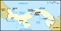
Our Panama trip guidebook created by Overseas Adventure Travel (OAT) was so frustratingly wrong on many points but especially with the order of things in transit on the canal. In addition they had provided vague descriptions of what we would do and see throughout the trip, so much so that I spent much more time than I would have wanted correcting badly written and edited information so that I could have a clear understanding of our journey. We had been given no maps by OAT and because of that, coupled with loads of inaccuracies, I was thrilled to finally see a large map of the canal and the
region surrounding it posted near the bar aboard ship where I was finally able to make sense of where we had been and where we were going. The crew on board also helped to clarify the misinformation allowing us to be truly excited to begin this transit from the Atlantic to the Pacific through the Panama Canal.
As we departed Shelter Bay we saw four
old shipwrecks left to decay in the mangroves, one of them upside down and another sailboat whose large mast was now pointing toward the canal that reminded us that it is not always easy sailing. It was not long before we were underway from our dock in Shelter Bay towards Limon Bay. With the Atlantic Ocean to our left we turned toward Lake Gatun at the Cristobal breakwater toward the first set of locks from the Caribbean into the Panama Canal.
The Panama Canal is 80.5 km long connecting the Atlantic and Pacific Oceans on a northwest to southeast (or reverse) direction through the narrow isthmus of Panama. Our journey took us northwest to southeast. This lock-type canal is owned and administered by the Republic of Panama. A licensed and trained
Panama Canal Entering the Pedro Miguel Lock
The tracks for the mules on either side of the lock are clearly visible here. Authority Pilot is compulsory in canal waters to assist a captain through the locks. Because of this the Panama Canal enjoys an excellent safety record. While we waited for our pilot’s small
Panama Canal Authority Ferry Boat to arrive with our
PCA Pilot, we spent time observing the many brightly colored large container ships, sailboats and other craft that waited in the bay for their turn to enter the beginning of the canal. If a vessel is not scheduled to transit that day, it will drop anchor and wait for its scheduled time. We were excited.
It seemed to take a long time for us to be under way with our new pilot but I am sure it was because we all were anxious to begin this exciting part of our trip. The pilot and captain motored our little ship following several large container ships under the yet to be completed
Atlantic Bridge to our first leg of the Panama Canal.
Feeling quite a bit dwarfed, we followed the Emerald, a container ship from Valletta, Malta carrying refrigerated cargo storage into Gatun Locks, the first of our locks in the Panama Canal. The dark walls of the chamber’s
Leaving the Pedro Miguel lock
Note the double gates that are in place to control the water leaving the lock, preventing a massive flood downstream. locks seemed too narrow to handle such a large ship but with the
“lock mules”, the Panama Canal towing locomotive, the ship was perfectly positioned in the canal and evenly spaced in the chamber allowing for a minimum of 2 feet of clearance on each side of the ship.
These “mules” (named after the animals traditionally used to cross the isthmus of Panama) date back to the beginning of the canal and were considered an important safety feature to keep ships from running into the lock walls. The
mules run on tracks along the upper edge of the chamber walls. Electric power supplied by a third rail below the surface level on the land side is used to propel the mules. Each mule is operated by a driver who uses a winch to pay out the heavy cable that attaches to the ship to keep it in place. Nice to know they did have brakes.
We followed the Emerald as she went into position and then we were also guided and, because we were a small vessel, were manually roped to the huge approach wall by line handlers on our ship. We then watched the large gates slowly
close behind us. Thus began the slow two hour process of the opening and closing of each of the lock gates inside the three massive lock chambers while raising and lowering the water levels as we traveled on our way to Lake Gatun.
The lock chambers are massive, 110 ft wide by 1,050 ft long. Those dimensions were determined by the maximum size of ships (at the time) that would be using the canal. The total lift or the height that the ship is raised is 85 feet in the Gatun locks. By comparison, the Miraflores locks have a two step lift of 54 feet and the Pedro Miguel locks have a single step of only 31 feet. We were all impressed watching the slow movement of these enormous gates, realizing their job is to hold back the considerable weight of water that, if the mechanism failed, could unleash a catastrophic flood of water downstream.
Abdiel told us the Panama Canal can take up to 40 vessels per day at a cost of 7-9 million dollars per day with a net of approximately 5-6 million dollars. It cost our small ship $5,000 to pass through the canal while
large ships average $800,000 to cross the canal. Millions of dollars of water are poured into this canal daily, much of it from Gatun Lake. In spite of the seemingly huge price tag, it is still a savings for major vessels both in time and money compared to an arduous crossing around Cape Horn.
We had two chambers to go and were heading to the second one but then…. it was over. We had moved to the last or third chamber which carried us to the highest elevation allowing us to enter
Gatun Lake, the world’s second largest man made lake. In the fading light of the afternoon, we motored past the new Agua Clara locks and set anchor across from the Gatun Yacht Club where we would spend the next three nights aboard the Discovery.
Gatun Lake, created between 1907 and 1913, is 164 square miles and 86 feet above sea level. The lake is located in the valley of the Chagres River. The river was widened and deepened by constructing the Gatun Dam thus creating this lake, integral to the movement of ships across the Panama Canal. Because this area was once a tropical jungle, old
tops of mahogany trees can still be seen rising from the water. Submerged snags present a hazard for small vessels that wander off the marked channels. We learned the National Geographic eco-tour ship is the only other ship allowed to anchor in Lake Gatun. That was pretty exciting news! From our position we could see the Tiger Islands where we would motor the next day to find the fabulous flora and fauna of this area.
Advertisement
Tot: 0.14s; Tpl: 0.017s; cc: 6; qc: 24; dbt: 0.0466s; 1; m:domysql w:travelblog (10.17.0.13); sld: 1;
; mem: 1.1mb