Cerro Negro y El Hoyo
Advertisement
Published: July 18th 2011

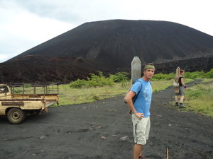
 First View of Cerro Negro
The hill is the slope on the left side of the photo. I took this 30 km trek with Quetzal Trekkers (http://www.quetzaltrekkers.com/) , a non-profit organization located in Leon (and that originated in Guatemala). The $69 cost is pretty expensive by Nicaragua standards, but it included everything: food, transportation, volcano-boarding tents, guides, park entry, a free t-shirt, and any equipment you need. Besides, the money goes to a good cause. There are a some other similar organizations in Leon that conduct tours for other causes.
CERRO NEGRO HIKE AND VOLCANO-BOARDING (45 minutes hiking up the hill, 45 seconds down)
We began the trip with breakfast at the Quetzal Trekkers headquarters in Leon. From there we piled into a camioneta for a bumpy one-hour ride to Cerro Negro. My first glimpse of the volcano was disconcerting -- picturing myself sliding down the steep 700 meters (around 2200 feet) of volcanic sand was difficult to imagine. We strapped our boards onto our backs and began the 45 minutes hike up the southern end of the volcano. Some parts are difficult, as you have to scramble up loose rock / scree, but we were lucky to have a cool, cloudy day and it was much easier than it had looked. Once at the top,
the guide gave us some information about the craters and the eruptions and then gave us instructions on how to use the boards.
There were some people learning how to use snowboards to go down the slope, which didn't look very fun at all. Because of the near-40-degree angle and packed sand, it looks like someone would shoot right down the hill, but they struggled to move at all. Apparently, sled riding on a specially-made board moves much faster and is much easier. All of the agencies supply special suits, gloves, googles, and a formica-coated board. Bigfoot hostel also clocks the speed of everyone and gives free mojitos to any record-breakers. The Israeli girl who has the current record -- 87 kph -- apparently broke her face (as one worker described it), so it hardly seems worth it to race. Instead, I decided to take my time (I maybe got up to 30 km / hour) and found it to be fairly easy if you have ever gone sled riding.
Here is a youtube video someone else made of the experience:
">
EL HOYO (4-5 hours of hiking each day)
After the volcano boarding, we began

 Campsite
My tent was just below one of the craters at El Hoyo.our hike to El Hoyo. The first part of this hike, in particular, is pretty difficult, especially because there are no water sources during most of the trek, and the agency had each person carry about 8 liters of water, which I found to be excessive. As a result, my pack was much heavier than I prefer (maybe 45 lbs), so the first hour of walking straight up the volcano was pretty grueling.
There are several crossroads and it would be very easy to get lost, so I wouldn't try this alone. We had two American guides (all of whom are volunteers-- Quetzal has a 3-month minimum) who were friendly and helpful. The trails were a mix of sand, volcanic rocks, and compacted dirt, so good shoes are needed. I wore sandals without a problem, but in a few areas would have been more comfortable with boots. A trekking pole would really help in some areas as well.
After reaching near the top of Volcan Las Pislas, the trail flattens out significantly; it started to rain as and we passed a dead crater / caldera before reaching the spectacular campsite at El Hoyo (1,050 meters; see photos). Really,

 Dead Tree in Fog
Much of the hike was through dense clouds.the view is the only thing that makes this area worthwhile for camping. The whole area is covered in cow shit and at this altitude, the high winds are often a problem. When we arrived, it had just stopped raining, and we took that opportunity to set up our tents. A brief break from the downpour gave us a chance to see our surroundings, which were incredible (see video). Unfortunately, the clouds came back and we spent much of the rest of our night in our tents. If you have your own equipment, I recommend taking it on this hike; Quetzal's packs, sleeping pads, sleeping bags, and tents are well-used and some people had problems with them getting wet and smelling-- they should definitely try to get some new equipment donated to them.
There is no escape from the noise in Nicaragua. Motors and bass and beeping and car alarms and fireworks and pounding and political ads make it impossible to find silence in the cities, but even in places that are supposed to be 'muy tranquilo' are often polluted with these sounds. We were at least ten miles from any town, but toward the end of dinner (and
just before bed, as it started to rain again), we began to hear the unmistakable sound of a discoteca in the distance. Even with my earplugs in, the bass sounded like it was right next door, and because of the music, as well as the strong winds blowing water under my tent, I got very little sleep.
I was secretly happy that it was foggy at 4:30 AM, when we were supposed to wake up to see the sunrise. At around 6:30 we had cold oatmeal for breakfast and then headed down the volcano without getting to look into the crater that we slept beneath. It was extremely steep and slippery and the weather changed from fog to rain. After about 20 minutes it became a slightly downward grade for the next few hours to Laguna Asososca, where just as the clouds cleared and sun finally came out, we took a dip in the water. From there it was just an hour more to the road where we would find a camioneta to take us the two hours back to Leon.
Since I enjoyed the trek despite the rain, I highly recommend it to anyone who visits Leon.
Advertisement
Tot: 0.083s; Tpl: 0.011s; cc: 9; qc: 34; dbt: 0.04s; 1; m:domysql w:travelblog (10.17.0.13); sld: 1;
; mem: 1.1mb


