Guadeloupe Geography, Guadeloupe Geography
Advertisement
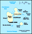
Location: Caribbean, islands between the Caribbean Sea and the North Atlantic Ocean, southeast of Puerto Rico
Geographic coordinates: 16 15 N, 61 35 W
Map references: Central America and the Caribbean
Area: Total: 1,780 sq km land: 1,706 sq km water: 74 sq km note: Guadeloupe is an archipelago of nine inhabited islands, including Basse-Terre, Grande-Terre, Marie-Galante, La Desirade, Iles des Saintes (2), Saint-Barthelemy, Iles de la Petite Terre, and Saint-Martin (French part of the island of Saint Martin)
Area - comparative: 10 times the size of Washington, DC
Land boundaries: Total: 10.2 km border countries: Netherlands Antilles (Sint Maarten) 10.2 km
Coastline: 306 km
Maritime claims: Territorial sea: 12 nm exclusive economic zone: 200 nm
Climate: Subtropical tempered by trade winds; moderately high humidity
Terrain: Basse-Terre is volcanic in origin with interior mountains; Grande-Terre is low limestone formation; most of the seven other islands are volcanic in origin
Elevation extremes: Lowest point: Caribbean Sea 0 m highest point: Soufriere 1,484 m
Natural resources: Cultivable land, beaches and climate that foster tourism
Land use: Arable land: 11.24% permanent crops: 3.55% other: 85.21% (2001)
Irrigated land: 20 sq km (1998 est.)
Natural hazards: Hurricanes (June to October); Soufriere de Guadeloupe is an active volcano
Environment - current issues: NA
Environment - international agreements:
Geography - note: A narrow channel, the Riviere Salee, divides Guadeloupe proper into two islands: the larger, western Basse-Terre and the smaller, eastern Grande-Terre
Advertisement
The information here has been derived from Public Domain Sources such as the CIA World Factbook. No liability can be taken for any inaccuracies.
Tot: 0.041s; Tpl: 0.008s; cc: 6; qc: 8; dbt: 0.007s; 1; m:domysql w:travelblog (10.17.0.13); sld: 1;
; mem: 1.1mb
 Guadeloupe has been a French possession since 1635. The island of Saint Martin is shared with the Netherlands; its southern portion is named Sint Maarten and is part of the Netherlands Antilles and its northern portion is named Saint-Martin and is pa...