Anguillan Geography, Anguilla Geography
Advertisement
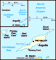
Location: Caribbean, islands between the Caribbean Sea and North Atlantic Ocean, east of Puerto Rico
Geographic coordinates: 18 15 N, 63 10 W
Map references: Central America and the Caribbean
Area: Total: 102 sq km land: 102 sq km water: 0 sq km
Area - comparative: About half the size of Washington, DC
Land boundaries: 0 km
Coastline: 61 km
Maritime claims: Territorial sea: 3 nm exclusive fishing zone: 200 nm
Climate: Tropical; moderated by northeast trade winds
Terrain: Flat and low-lying island of coral and limestone
Elevation extremes: Lowest point: Caribbean Sea 0 m highest point: Crocus Hill 65 m
Natural resources: Salt, fish, lobster
Land use: Arable land: 0% permanent crops: 0% other: 100% (mostly rock with sparse scrub oak, few trees, some commercial salt ponds) (2001)
Irrigated land: NA
Natural hazards: Frequent hurricanes and other tropical storms (July to October)
Environment - current issues: Supplies of potable water sometimes cannot meet increasing demand largely because of poor distribution system
Environment - international agreements:
Geography - note: The most northerly of the Leeward Islands in the Lesser Antilles
Advertisement
The information here has been derived from Public Domain Sources such as the CIA World Factbook. No liability can be taken for any inaccuracies.
Tot: 0.031s; Tpl: 0.009s; cc: 5; qc: 8; dbt: 0.0077s; 1; m:domysql w:travelblog (10.17.0.13); sld: 1;
; mem: 1.1mb
 Colonized by English settlers from Saint Kitts in 1650, Anguilla was administered by Great Britain until the early 19th century, when the island - against the wishes of the inhabitants - was incorporated into a single British dependency, along with S...