Advertisement
Published: April 24th 2007

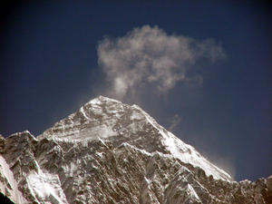
 The top of Everest
Peeking out obove Nuptse, taken just after Namche While the first half of my trek,
Jiri to Namche, was all about the Nepali (mostly Sherpa) people that I met along the way, this second part deals mainly with Nepal’s rockier residents.
From Namche Bazaar (3450 m / 11320 ft), I initially headed northeast towards Everest. This is when I saw the dramatic thumb-like Ama Dablam and caught my first glimpse of Everest (since its fleeting apparition in Tibet in 2005) peeking out from behind its daughters Nuptse and Lhotse (photos). I branched North after a few hours to ascend the Gokyo Valley towards Nepal's largest glacier, Ngozumpa, then ultimately to the top of Gokyo Ri at approximately 5400m / 17700 ft.
Up, stop. Up, stop. It took me 4 frustratingly short days to reach the village of Gokyo from Namche. Because the Gokyo valley rises constantly, it's important not to climb too high too fast and thus risk serious altitude sickness. Several trekkers and Nepalis alike have died from acute mountain sickness here and the Himalayan Rescue Association recommends a net daily ascent of no more than 400m (1300 ft). In the Gokyo Valley, this can mean stopping for the day at 9:30 AM after as little as

 The Trek from Namche to Gokyo Ri
Not shown is my detour to Tengboche on the way back. Google Earth is cool!1.5 to 2 hours of uphill walking. It is very tempting to continue to the next village only a couple of hours away and a few hundred meters higher, as some people do despite the warnings.
Visual Gluttony: On my 5th day after Namche, I got up at 5 AM and climbed to the top of Gokyo Ri for one of the most spectacular mountain panoramas on earth. I think the appreciation of a view is somehow proportional to the effort spent getting to it. After 36 hours sitting on planes and bus, and 15 days slogging up and down steep mountain trails, this view was well earned.
Panning from left to right, I saw (among many others) Cho Oyu (8201 m / 26906 ft), Gyachung Kang (7922 m / 25991 ft), Everest (8848 m / 29021 ft), Nuptse (7879 m / 25850 ft), Lhotse (8501 m / 27890 ft), Makalu (8463 m / 27766 ft), all set behind the swoosh-shaped Ngozumpa Glacier. That's 4 of the world's top 6 mountains and one of its largest glaciers spread out in a gigantic smorgasbord for the eyes. See the photos, but they can never do justice. I devoured the
view for almost 2 hours atop Gokyo Ri until clouds started envelopping the mountains.
What goes up must come down, faster: It took me only 4 days to walk down from Gokyo to Lukla (versus 1 week going up) including a detour to Tengboche Monastery. The trip back was when I spotted most of the wildlife (photos) including Himalayan ducks, a snow pigeon, a beautiful Impeyan pheasant and a herd of Himalayan tahr.
Pushing your Lukla: Lukla Airport(altitude 2800 m / 9200 ft) must have one of the highest, shortest and steepest commercial runways in the world, and it's Nepal's 3rd busiest! The stubby 450 m / 1500 ft runway (half the length of tiny St-Lazare airfield in Montreal) is punctuated at one end by a cliff and at the other by a rock face. The rock face end is 60 m (200 ft) higher than the cliff end, making it resemble a ski jump ramp. There's not much opportunity to abort a take-off or landing here.
The flight to Kathmandu was something like a flying version of my public bus ride to Jiri, but much shorter and without the luggage and passengers on the roof (I

 View from the trail just past Namche
In the background, the top of Everest peeks out over Nuptse, with Lhotse on right (world's 4 highest peak)presume). We were herded onto an old Yeti Airlines Twin-Otter, grabbing any seat. Seatbelts were available but apparently optional. There were no passenger instructions or announcements at all and not much in the way of pre-flight checks that I could see. The pilot glanced over his shoulder to see if everyone was onboard, pointed the plane downhill and opened throttles. We lifted off just before the cliff-edge and immediately banked left to avoid the large hill obstructing the take-off path.
I'm back in Kathmandu now and will soon start making my way home via Bangkok, Hong Kong and Vancouver.
Advertisement
Tot: 0.197s; Tpl: 0.012s; cc: 14; qc: 78; dbt: 0.0865s; 1; m:domysql w:travelblog (10.17.0.13); sld: 1;
; mem: 1.2mb

 The top of Everest
 The Trek from Namche to Gokyo Ri
 View from the trail just past Namche


Krispy
non-member comment
Someday
Oh HOW I want to experience this. I will speak for SO many when I say... I AM SO BLOODY JEALOUS!!!!!