Advertisement
Published: August 11th 2020

Heading to North base campKanchenjunga is the second highest mountain in Nepal and the third highest in the world, which is located in the far east of Nepal. Two base camps have been set up north and south of Kanchenjunga. The trek falls within the Kanchenjunga Conservation Area, the longest trekking in Nepal (excluding the Great Himalayan Trail). Most of the tourists initially visit the northern base camp and head towards the southern base camp.
As it takes more than 3 weeks to trek, only a few tourists reach there. Due to geographical remoteness and low tourist arrivals, the area is still completely isolated from outside influences. The locals have to come to the district headquarter Phung Ling Bazar to buy all the necessary goods. It takes about a week for the residents of the upper region. The main occupation of the lower region is cardamom cultivation while the upper region is engaged in animal husbandry and herbal trade.
Usually the journey also starts from Phung Ling Bazar to the rural settlements with a very simple lifestyle.
People are very friendly and helpful. After 3-4 days, human settlements are found only partially, most of the trekking is through the forest.
The
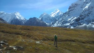
Observing Kanchanjanga from North base camp - Pangpemajourney is a bit difficult as we have to go up and down the narrow path. Since there is no phone facility, it is completely away from the outside world.
Freed from the hustle and bustle of the city, we will experience an absolutely peaceful atmosphere. During the spring and summer seasons, wildflowers of various species bloom.
When we reach Ghunsa village through dense forest and rivers, its beauty with even minimal service-facilities make us forget the geographical disadvantage.
Then when Khambachen arrives, the fully open and large step zone begins. On the right side very impressive Kumba Karna and many other mountains are visible. Countless yaks and blue sheeps are found grazing along the way. The farther we go, the closer the icebergs appear. Then probably the most beautiful place of this route located in the grassland reaches Lonak. From Lonak, we can reach the northern base camp Pangpema by overlooking the Kanchan Jung Glacier with many mountains . From here, there is a wonderful view of KanchanJunga Himalaya with its three heads. Then turn the same way to Ghunsa and cross the Selele pass towards the southern base camp. From the Selele Pass, Kumba Karna
LonakHimalaya range can be seen in the north and Makalu Himalaya range in the west. As we descend from Selele, we see a unique combination of Yalung Kang, Yalung Glacier and the river that flows from there on the east side, a scene that will truly amaze anyone. The path then passes through an open phase area and reaches the southern base camp of Kanchan Janga.
Although the view from the southern base camp is not as close as it is from northern base camp, the view around the southern base camp is quite different & pretty impressive.. After that, the journey ends at Bhadrapur through Cheram, Yamphudin and Ghatte Khola.
Advertisement
Tot: 0.078s; Tpl: 0.012s; cc: 10; qc: 50; dbt: 0.0403s; 1; m:domysql w:travelblog (10.17.0.13); sld: 1;
; mem: 1.1mb


