Advertisement
Published: April 23rd 2015

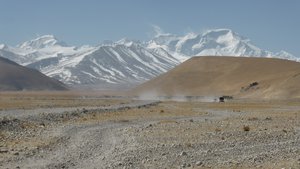
 Mt Cho Oyuon right (8201 mtrs)
5th or 6th highest. This is the Chinese name. Probably has a more well known English name. Just like Everest is known as Qomolangma.Despite 10 days of acclimatisation almost all the group had some degree of breathlessness, headaches and lack of sleep last night. While cold there was ample bedding to stay walm with the problem due to very hard beds, difficulty breathing at the altitude & only squat loos 3 floors up. Despite this waking to a clear sunrise was some compensation for the discomfort.
The day ahead was another 240 km over 8 hrs. We had to retrace the corrugated road down the mtn back to the highway, a juddering 60 kms over 3.5 hrs but still a suitable time to reflect on a wonderful experience, while not life changing, it will still be remembered for the rest of our life.
The rest of the trip was still substantially at altitude with our last pass (Lalong La Pass 5042mtrs) before quickly dropping by 1500 mtrs down the spectacular Sun Kosi Gorge to our overnight stop at the small village of Nyalam.
The view at the Lalong La pass was a stunning panorama with a sea of snow on the lower plains leading up to the mtns until completely surrounded by snow capped mtns at the top. The road as
late as last week was closed due to a heavy snow storm & still only half open.
Advertisement
Tot: 0.296s; Tpl: 0.012s; cc: 9; qc: 50; dbt: 0.1847s; 1; m:domysql w:travelblog (10.17.0.13); sld: 1;
; mem: 1.1mb

 Mt Cho Oyuon right (8201 mtrs)