Advertisement
Published: April 3rd 2014
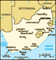
Stellenboch to L’Agulhas (144 miles)--Friday, February 28
th Travelling on Highway R44 on the Whale Coast Drive (unfortunately the wrong time of year for the whales), after 82 km we turned onto R43 toward Hermanus. After about 22 km, we navigated the traffic circle and turned toward Stanford, a few more km and we turned onto Highway R316 toward Napier/Bredasdorp. We turned right at a sign for Cape Agulhas now on 319, and drove to the “Southernmost tip of Africa” where we looked at the rocks, the oceans (Indian on the left and Atlantic Ocean on right), and the lighthouse before driving a few km back to L’Agulhas Caravan Park for the night.
Driving this route we travelled along the coast through small communities at first. We stopped in one small town at a ShopRite and ought some plastic ware that we hadn’t found before—“silverware,” water jugs to fit the refrig door, etc. In the parking lot we saw an interesting bird that we don’t recognize even going page by page in the bird book.
As we came around one of the curves, we spotted baboons next to the road—the hills were covered with dry shrub at
this point. We didn’t think that was where baboons live. Stopped at several pull-offs and looked at the pretty bays and upscale homes.
As we went inland, the land was filled with rolling hills covered in huge wheat farms. In the fields we spotted a family of blue cranes with Dad on guard while mom and chick ate, some Egyptian ducks, several small herds of antelope, and I think some black-swans near a pond. Plenty of hawks were spotted in the trees, but with so many kinds of hawks in this part of the world, it is hard for us to ID with just a glance as we drive by.
Pulled off at a rest stop overlooking a valley and had lunch. Travelled some more through small communities with attractive churches—many Dutch Reformed. Dutch influence still found here in the building style in Bredasdorp. We drovearound some of the side streets in the town of Bredasdorp looking at thatched roofed businesses and at interesting old churches
We were really surprised at “Land’s End” to find the rocks in the water sharp and jagged. After millions of years of wave action we expected rocks more rounded and smooth
like those found along the Maine Coast. Lots of succulents like ice plant, growing in the sand just like near the California beaches.
L’Agulhas to Riversdale (196km or 122 miles)—Saturday, March, 2014
We continued on highway R-319 toward Swellendam and turned off on the other side of Bredasdorp to go to the Kapula Candles and gift shop. We missed the next turn and went a block or two too far which brought us almost into a Township, which we knew was not the direction we wanted to go. As Valerie turned around, I spotted a large group of people walking and a line of cars following. We realized it was a funeral procession and the person in the lead was dressed in a white flowing shirt and white pants. We drove back and found the store and bought a few items like an African-themed candle egg to add to Mom’s egg collection and a beaded “doll” for our Christmas tree ornament collection.
We continued driving through wheat fields and land that looked a lot like Montana or Wyoming. Sheep and cattle in the fields with wild ostriches here and there, some with chicks. Also ostrich farms with
pens or just being raised in fields like cattle.
We made our way to the N-2 and after about 100 km came to the outskirts of the town of Swellendam. The Dutch East India Company made this a district in 1743 which makes it the third oldest white settlement in South Africa. We drove down the main street and then pulled into a parking lot across from a pretty elaborate Dutch Reformed Church built in 1901. We then noticed a very small Saturday market with some food stalls in back of some shops. We each got a vegetarian crepe-like pastry for a snack and wandered around looking at the other items for sale.
Got back into the RV and then proceeded across the main road to the entrance to Bontebok National Park. This very dry reserve is home to the Bontebok Antelope as well as other species of antelope and some zebra. We got out and registered the RV showing them a pass called the “Wild Card,” which with one fee (included in the tour) is good for entry into all the National Parks and some reserves.
We drove into the park on the pot-holey dirt road
and proceeded to follow the Park map in a self-guided tour. Some of the hilly inclines had brick-like tracks to cut down on erosion and keep you from getting stuck. We drove toward the picnic area to have our lunch and found a group of South Africans having lunch at the next picnic table. Valerie had on a Featherfest T-shirt from Galveston, Texas and one of the men commented on it. He is an ornithologist and so we showed him some of the birds we wanted ID’ed. We had a very pleasant chat with him and the others in his group. We didn’t see any birds but did see a number of odd and interesting blooming flowers in this fynbos zone.
We got back on the N-2 and continued toward the town of Riversdale where we spent the night at the Takkieskloof Caravan Park.
Advertisement
Tot: 0.077s; Tpl: 0.016s; cc: 12; qc: 31; dbt: 0.0286s; 1; m:domysql w:travelblog (10.17.0.13); sld: 1;
; mem: 1.1mb


