Gabonese Geography, Gabon Geography
Advertisement
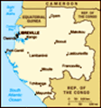
Location: Western Africa, bordering the Atlantic Ocean at the Equator, between Republic of the Congo and Equatorial Guinea
Geographic coordinates: 1 00 S, 11 45 E
Map references: Africa
Area: Total: 267,667 sq km land: 257,667 sq km water: 10,000 sq km
Area - comparative: Slightly smaller than Colorado
Land boundaries: Total: 2,551 km border countries: Cameroon 298 km, Republic of the Congo 1,903 km, Equatorial Guinea 350 km
Coastline: 885 km
Maritime claims: Territorial sea: 12 nm contiguous zone: 24 nm exclusive economic zone: 200 nm
Climate: Tropical; always hot, humid
Terrain: Narrow coastal plain; hilly interior; savanna in east and south
Elevation extremes: Lowest point: Atlantic Ocean 0 m highest point: Mont Iboundji 1,575 m
Natural resources: Petroleum, natural gas, diamond, niobium, manganese, uranium, gold, timber, iron ore, hydropower
Land use: Arable land: 1.26% permanent crops: 0.66% other: 98.08% (2001)
Irrigated land: 150 sq km (1998 est.)
Natural hazards: NA
Environment - current issues: Deforestation; poaching
Environment - international agreements: Party to: Biodiversity, Climate Change, Desertification, Endangered Species, Law of the Sea, Marine Dumping, Ozone Layer Protection, Ship Pollution, Tropical Timber 83, Tropical Timber 94, Wetlands signed, but not ratified: none of the selected agreements
Geography - note: A small population and oil and mineral reserves have helped Gabon become one of Africa's wealthier countries; in general, these circumstances have allowed the country to maintain and conserve its pristine rain forest and rich biodiversity
Advertisement
The information here has been derived from Public Domain Sources such as the CIA World Factbook. No liability can be taken for any inaccuracies.
Tot: 0.042s; Tpl: 0.007s; cc: 3; qc: 10; dbt: 0.0111s; 1; m:domysql w:travelblog (10.17.0.13); sld: 1;
; mem: 1.1mb
 Only two autocratic presidents have ruled Gabon since independence from France in 1960. Gabon's current President, El Hadj Omar BONGO Ondimba - one of the longest-serving heads of state in the world - has dominated Gabon's political scene for almost ...