Malaysian Geography, Malaysia Geography
Advertisement
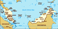
Location: Southeastern Asia, peninsula bordering Thailand and northern one-third of the island of Borneo, bordering Indonesia, Brunei, and the South China Sea, south of Vietnam
Geographic coordinates: 2 30 N, 112 30 E
Map references: Southeast Asia
Area: Total: 329,750 sq km land: 328,550 sq km water: 1,200 sq km
Area - comparative: Slightly larger than New Mexico
Land boundaries: Total: 2,669 km border countries: Brunei 381 km, Indonesia 1,782 km, Thailand 506 km
Coastline: 4,675 km (Peninsular Malaysia 2,068 km, East Malaysia 2,607 km)
Maritime claims: Territorial sea: 12 nm exclusive economic zone: 200 nm continental shelf: 200-m depth or to the depth of exploitation; specified boundary in the South China Sea
Climate: Tropical; annual southwest (April to October) and northeast (October to February) monsoons
Terrain: Coastal plains rising to hills and mountains
Elevation extremes: Lowest point: Indian Ocean 0 m highest point: Gunung Kinabalu 4,100 m
Natural resources: Tin, petroleum, timber, copper, iron ore, natural gas, bauxite
Land use: Arable land: 5.48% permanent crops: 17.61% other: 76.91% (2001)
Irrigated land: 3,650 sq km (1998 est.)
Natural hazards: Flooding, landslides, forest fires
Environment - current issues: Air pollution from industrial and vehicular emissions; water pollution from raw sewage; deforestation; smoke/haze from Indonesian forest fires
Environment - international agreements: Party to: Biodiversity, Climate Change, Climate Change-Kyoto Protocol, Desertification, Endangered Species, Hazardous Wastes, Law of the Sea, Marine Life Conservation, Ozone Layer Protection, Ship Pollution, Tropical Timber 83, Tropical Timber 94, Wetlands
Geography - note: Strategic location along Strait of Malacca and southern South China Sea
Advertisement
The information here has been derived from Public Domain Sources such as the CIA World Factbook. No liability can be taken for any inaccuracies.
Tot: 0.029s; Tpl: 0.007s; cc: 3; qc: 2; dbt: 0.0034s; 1; m:domysql w:travelblog (10.17.0.13); sld: 1;
; mem: 1.1mb
 During the late 18th and 19th centuries, Great Britain established colonies and protectorates in the area of current Malaysia; these were occupied by Japan from 1942 to 1945. In 1948, the British-ruled territories on the Malay Peninsula formed the Fe...