Liberian Geography, Liberia Geography
Advertisement
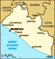
Location: Western Africa, bordering the North Atlantic Ocean, between Cote d'Ivoire and Sierra Leone
Geographic coordinates: 6 30 N, 9 30 W
Map references: Africa
Area: Total: 111,370 sq km land: 96,320 sq km water: 15,050 sq km
Area - comparative: Slightly larger than Tennessee
Land boundaries: Total: 1,585 km border countries: Guinea 563 km, Cote d'Ivoire 716 km, Sierra Leone 306 km
Coastline: 579 km
Maritime claims: Territorial sea: 200 nm
Climate: Tropical; hot, humid; dry winters with hot days and cool to cold nights; wet, cloudy summers with frequent heavy showers
Terrain: Mostly flat to rolling coastal plains rising to rolling plateau and low mountains in northeast
Elevation extremes: Lowest point: Atlantic Ocean 0 m highest point: Mount Wuteve 1,380 m
Natural resources: Iron ore, timber, diamonds, gold, hydropower
Land use: Arable land: 3.95% permanent crops: 2.28% other: 93.77% (2001)
Irrigated land: 30 sq km (1998 est.)
Natural hazards: Dust-laden harmattan winds blow from the Sahara (December to March)
Environment - current issues: Tropical rain forest deforestation; soil erosion; loss of biodiversity; pollution of coastal waters from oil residue and raw sewage
Environment - international agreements: Party to: Biodiversity, Climate Change, Climate Change-Kyoto Protocol, Desertification, Endangered Species, Ozone Layer Protection, Ship Pollution, Tropical Timber 83, Tropical Timber 94 signed, but not ratified: Environmental Modification, Law of the Sea, Marine Life Conservation
Geography - note: Facing the Atlantic Ocean, the coastline is characterized by lagoons, mangrove swamps, and river-deposited sandbars; the inland grassy plateau supports limited agriculture
Advertisement
The information here has been derived from Public Domain Sources such as the CIA World Factbook. No liability can be taken for any inaccuracies.
Tot: 0.042s; Tpl: 0.007s; cc: 6; qc: 6; dbt: 0.0094s; 1; m:domysql w:travelblog (10.17.0.13); sld: 1;
; mem: 1.1mb
 In August 2003, a comprehensive peace agreement ended 14 years of civil war and prompted the resignation of former president Charles TAYLOR, who was exiled to Nigeria. The National Transitional Government of Liberia (NTGL) - composed of rebel, govern...