Haitian Geography, Haiti Geography
Advertisement
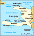
Location: Caribbean, western one-third of the island of Hispaniola, between the Caribbean Sea and the North Atlantic Ocean, west of the Dominican Republic
Geographic coordinates: 19 00 N, 72 25 W
Map references: Central America and the Caribbean
Area: Total: 27,750 sq km land: 27,560 sq km water: 190 sq km
Area - comparative: Slightly smaller than Maryland
Land boundaries: Total: 360 km border countries: Dominican Republic 360 km
Coastline: 1,771 km
Maritime claims: Territorial sea: 12 nm contiguous zone: 24 nm exclusive economic zone: 200 nm continental shelf: to depth of exploitation
Climate: Tropical; semiarid where mountains in east cut off trade winds
Terrain: Mostly rough and mountainous
Elevation extremes: Lowest point: Caribbean Sea 0 m highest point: Chaine de la Selle 2,680 m
Natural resources: Bauxite, copper, calcium carbonate, gold, marble, hydropower
Land use: Arable land: 28.3% permanent crops: 11.61% other: 60.09% (2001)
Irrigated land: 750 sq km (1998 est.)
Natural hazards: Lies in the middle of the hurricane belt and subject to severe storms from June to October; occasional flooding and earthquakes; periodic droughts
Environment - current issues: Extensive deforestation (much of the remaining forested land is being cleared for agriculture and used as fuel); soil erosion; inadequate supplies of potable water
Environment - international agreements: Party to: Biodiversity, Climate Change, Desertification, Law of the Sea, Marine Dumping, Marine Life Conservation, Ozone Layer Protection signed, but not ratified: Hazardous Wastes
Geography - note: Shares island of Hispaniola with Dominican Republic (western one-third is Haiti, eastern two-thirds is the Dominican Republic)
Advertisement
The information here has been derived from Public Domain Sources such as the CIA World Factbook. No liability can be taken for any inaccuracies.
Tot: 0.035s; Tpl: 0.007s; cc: 6; qc: 6; dbt: 0.0078s; 1; m:domysql w:travelblog (10.17.0.13); sld: 1;
; mem: 1.1mb
 The native Arawak Amerindians - who inhabited the island of Hispaniola when it was discovered by Columbus in 1492 - were virtually annihilated by Spanish settlers within 25 years. In the early 17th century, the French established a presence on Hispan...