Faroese Geography, Faroe Islands Geography
Advertisement
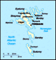
Location: Northern Europe, island group between the Norwegian Sea and the North Atlantic Ocean, about one-half of the way from Iceland to Norway
Geographic coordinates: 62 00 N, 7 00 W
Map references: Europe
Area: Total: 1,399 sq km land: 1,399 sq km water: 0 sq km (some lakes and streams)
Area - comparative: Eight times the size of Washington, DC
Land boundaries: 0 km
Coastline: 1,117 km
Maritime claims: Territorial sea: 3 nm continental shelf: 200 nm or agreed boundaries or median line exclusive fishing zone: 200 nm or agreed boundaries or median line
Climate: Mild winters, cool summers; usually overcast; foggy, windy
Terrain: Rugged, rocky, some low peaks; cliffs along most of coast
Elevation extremes: Lowest point: Atlantic Ocean 0 m highest point: Slaettaratindur 882 m
Natural resources: Fish, whales, hydropower, possible oil and gas
Land use: Arable land: 2.14% permanent crops: 0% other: 97.86% (2001)
Irrigated land: 0 sq km (1998 est.)
Natural hazards: NA
Environment - current issues: NA
Environment - international agreements:
Geography - note: Archipelago of 17 inhabited islands and one uninhabited island, and a few uninhabited islets; strategically located along important sea lanes in northeastern Atlantic; precipitous terrain limits habitation to small coastal lowlands
Advertisement
The information here has been derived from Public Domain Sources such as the CIA World Factbook. No liability can be taken for any inaccuracies.
Tot: 0.022s; Tpl: 0.007s; cc: 3; qc: 2; dbt: 0.0046s; 1; m:domysql w:travelblog (10.17.0.13); sld: 1;
; mem: 1.1mb
 The population of the Faroe Islands is largely descended from Viking settlers who arrived in the 9th century. The islands have been connected politically to Denmark since the 14th century. A high degree of self-government was attained in 1948....