Falkland Island Geography, Falkland Islands Geography
Advertisement
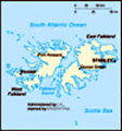
Location: Southern South America, islands in the South Atlantic Ocean, east of southern Argentina
Geographic coordinates: 51 45 S, 59 00 W
Map references: South America
Area: Total: 12,173 sq km land: 12,173 sq km water: 0 sq km note: includes the two main islands of East and West Falkland and about 200 small islands
Area - comparative: Slightly smaller than Connecticut
Land boundaries: 0 km
Coastline: 1,288 km
Maritime claims: Territorial sea: 12 nm continental shelf: 200 nm exclusive fishing zone: 200 nm
Climate: Cold marine; strong westerly winds, cloudy, humid; rain occurs on more than half of days in year; average annual rainfall is 24 inches in Stanley; occasional snow all year, except in January and February, but does not accumulate
Terrain: Rocky, hilly, mountainous with some boggy, undulating plains
Elevation extremes: Lowest point: Atlantic Ocean 0 m highest point: Mount Usborne 705 m
Natural resources: Fish, squid, wildlife, calcified seaweed, sphagnum moss
Land use: Arable land: 0% permanent crops: 0% other: 100% (99% permanent pastures, 1% other) (2001)
Irrigated land: NA sq km
Natural hazards: Strong winds persist throughout the year
Environment - current issues: Overfishing by unlicensed vessels is a problem; reindeer were introduced to the islands in 2001 for commercial reasons; this is the only commercial reindeer herd in the world unaffected by the Chornobyl disaster
Environment - international agreements:
Geography - note: Deeply indented coast provides good natural harbors; short growing season
Advertisement
The information here has been derived from Public Domain Sources such as the CIA World Factbook. No liability can be taken for any inaccuracies.
Tot: 0.025s; Tpl: 0.011s; cc: 3; qc: 2; dbt: 0.0037s; 1; m:domysql w:travelblog (10.17.0.13); sld: 1;
; mem: 1mb
 Although first sighted by an English navigator in 1592, the first landing (English) did not occur until almost a century later in 1690, and the first settlement (French) was not established until 1764. The colony was turned over to Spain two years la...