Tongan Geography, Tonga Geography
Advertisement
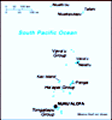
Location: Oceania, archipelago in the South Pacific Ocean, about two-thirds of the way from Hawaii to New Zealand
Geographic coordinates: 20 00 S, 175 00 W
Map references: Oceania
Area: Total: 748 sq km land: 718 sq km water: 30 sq km
Area - comparative: Four times the size of Washington, DC
Land boundaries: 0 km
Coastline: 419 km
Maritime claims: Territorial sea: 12 nm exclusive economic zone: 200 nm continental shelf: 200-m depth or to the depth of exploitation
Climate: Tropical; modified by trade winds; warm season (December to May), cool season (May to December)
Terrain: Most islands have limestone base formed from uplifted coral formation; others have limestone overlying volcanic base
Elevation extremes: Lowest point: Pacific Ocean 0 m highest point: unnamed location on Kao Island 1,033 m
Natural resources: Fish, fertile soil
Land use: Arable land: 23.61% permanent crops: 43.06% other: 33.33% (2001)
Irrigated land: NA
Natural hazards: Cyclones (October to April); earthquakes and volcanic activity on Fonuafo'ou
Environment - current issues: Deforestation results as more and more land is being cleared for agriculture and settlement; some damage to coral reefs from starfish and indiscriminate coral and shell collectors; overhunting threatens native sea turtle populations
Environment - international agreements: Party to: Biodiversity, Climate Change, Desertification, Law of the Sea, Marine Dumping, Marine Life Conservation, Ozone Layer Protection, Ship Pollution signed, but not ratified: none of the selected agreements
Geography - note: Archipelago of 169 islands (36 inhabited)
Advertisement
The information here has been derived from Public Domain Sources such as the CIA World Factbook. No liability can be taken for any inaccuracies.
Tot: 0.021s; Tpl: 0.008s; cc: 3; qc: 2; dbt: 0.0045s; 1; m:domysql w:travelblog (10.17.0.13); sld: 1;
; mem: 1mb
 The archipelago of "The Friendly Islands" was united into a Polynesian kingdom in 1845. It became a constitutional monarchy in 1875 and a British protectorate in 1900. Tonga acquired its independence in 1970 and became a member of the Commonwealth of...