Nauruan Geography, Nauru Geography
Advertisement
Location: Oceania, island in the South Pacific Ocean, south of the Marshall Islands
Geographic coordinates: 0 32 S, 166 55 E
Map references: Oceania
Area: Total: 21 sq km land: 21 sq km water: 0 sq km
Area - comparative: About 0.1 times the size of Washington, DC
Land boundaries: 0 km
Coastline: 30 km
Maritime claims: Territorial sea: 12 nm contiguous zone: 24 nm exclusive economic zone: 200 nm
Climate: Tropical with a monsoonal pattern; rainy season (November to February)
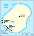
Terrain: Sandy beach rises to fertile ring around raised coral reefs with phosphate plateau in center
Elevation extremes: Lowest point: Pacific Ocean 0 m highest point: unnamed location along plateau rim 61 m
Natural resources: Phosphates, fish
Land use: Arable land: 0% permanent crops: 0% other: 100% (2001)
Irrigated land: NA
Natural hazards: Periodic droughts
Environment - current issues: Limited natural fresh water resources, roof storage tanks collect rainwater, but mostly dependent on a single, aging desalination plant; intensive phosphate mining during the past 90 years - mainly by a UK, Australia, and NZ consortium - has left the central 90% of Nauru a wasteland and threatens limited remaining land resources
Environment - international agreements: Party to: Biodiversity, Climate Change, Climate Change-Kyoto Protocol, Desertification, Hazardous Wastes, Law of the Sea, Marine Dumping, Ozone Layer Protection signed, but not ratified: none of the selected agreements
Geography - note: Nauru is one of the three great phosphate rock islands in the Pacific Ocean - the others are Banaba (Ocean Island) in Kiribati and Makatea in French Polynesia; only 53 km south of Equator
Advertisement
The information here has been derived from Public Domain Sources such as the CIA World Factbook. No liability can be taken for any inaccuracies.
Tot: 0.032s; Tpl: 0.007s; cc: 3; qc: 10; dbt: 0.009s; 1; m:domysql w:travelblog (10.17.0.13); sld: 1;
; mem: 1mb
 Nauru's phosphate deposits began to be mined early in the 20th century by a German-British consortium; the island was occupied by Australian forces in World War I. Nauru achieved independence in 1968 and joined the UN in 1999. Nauru is the world's sm...