Marshallese Geography, Marshall Islands Geography
Advertisement
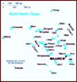
Location: Oceania, group of atolls and reefs in the North Pacific Ocean, about one-half of the way from Hawaii to Australia
Geographic coordinates: 9 00 N, 168 00 E
Map references: Oceania
Area: Total: 181.3 sq km land: 181.3 sq km water: 0 sq km note: includes the atolls of Bikini, Enewetak, Kwajalein, Majuro, Rongelap, and Utirik
Area - comparative: About the size of Washington, DC
Land boundaries: 0 km
Coastline: 370.4 km
Maritime claims: Territorial sea: 12 nm contiguous zone: 24 nm exclusive economic zone: 200 nm
Climate: Tropical; hot and humid; wet season from May to November; islands border typhoon belt
Terrain: Low coral limestone and sand islands
Elevation extremes: Lowest point: Pacific Ocean 0 m highest point: unnamed location on Likiep 10 m
Natural resources: Coconut products, marine products, deep seabed minerals
Land use: Arable land: 16.67% permanent crops: 38.89% other: 44.44% (2001)
Irrigated land: 0 sq km
Natural hazards: Infrequent typhoons
Environment - current issues: Inadequate supplies of potable water; pollution of Majuro lagoon from household waste and discharges from fishing vessels
Environment - international agreements: Party to: Biodiversity, Climate Change, Climate Change-Kyoto Protocol, Desertification, Hazardous Wastes, Law of the Sea, Ozone Layer Protection, Ship Pollution signed, but not ratified: none of the selected agreements
Geography - note: Two archipelagic island chains of 30 atolls and 1,152 islands; Bikini and Enewetak are former US nuclear test sites; Kwajalein, the famous World War II battleground, is now used as a US missile test range
Advertisement
The information here has been derived from Public Domain Sources such as the CIA World Factbook. No liability can be taken for any inaccuracies.
Tot: 0.029s; Tpl: 0.008s; cc: 6; qc: 6; dbt: 0.0069s; 1; m:domysql w:travelblog (10.17.0.13); sld: 1;
; mem: 1mb
 After almost four decades under US administration as the easternmost part of the UN Trust Territory of the Pacific Islands, the Marshall Islands attained independence in 1986 under a Compact of Free Association. Compensation claims continue as a resu...