Lebanese Geography, Lebanon Geography
Advertisement
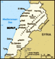
Location: Middle East, bordering the Mediterranean Sea, between Israel and Syria
Geographic coordinates: 33 50 N, 35 50 E
Map references: Middle East
Area: Total: 10,400 sq km land: 10,230 sq km water: 170 sq km
Area - comparative: About 0.7 times the size of Connecticut
Land boundaries: Total: 454 km border countries: Israel 79 km, Syria 375 km
Coastline: 225 km
Maritime claims: Territorial sea: 12 nm
Climate: Mediterranean; mild to cool, wet winters with hot, dry summers; Lebanon mountains experience heavy winter snows
Terrain: Narrow coastal plain; El Beqaa (Bekaa Valley) separates Lebanon and Anti-Lebanon Mountains
Elevation extremes: Lowest point: Mediterranean Sea 0 m highest point: Qurnat as Sawda' 3,088 m
Natural resources: Limestone, iron ore, salt, water-surplus state in a water-deficit region, arable land
Land use: Arable land: 16.62% permanent crops: 13.98% other: 69.4% (2001)
Irrigated land: 1,200 sq km (1998 est.)
Natural hazards: Dust storms, sandstorms
Environment - current issues: Deforestation; soil erosion; desertification; air pollution in Beirut from vehicular traffic and the burning of industrial wastes; pollution of coastal waters from raw sewage and oil spills
Environment - international agreements: Party to: Biodiversity, Climate Change, Desertification, Hazardous Wastes, Law of the Sea, Ozone Layer Protection, Ship Pollution, Wetlands signed, but not ratified: Environmental Modification, Marine Life Conservation
Geography - note: Nahr el Litani only major river in Near East not crossing an international boundary; rugged terrain historically helped isolate, protect, and develop numerous factional groups based on religion, clan, and ethnicity
Advertisement
The information here has been derived from Public Domain Sources such as the CIA World Factbook. No liability can be taken for any inaccuracies.
Tot: 0.044s; Tpl: 0.007s; cc: 3; qc: 8; dbt: 0.0133s; 1; m:domysql w:travelblog (10.17.0.13); sld: 1;
; mem: 1.1mb
 Lebanon has made progress toward rebuilding its political institutions since 1991 and the end of the devastating 15-year civil war. Under the Ta'if Accord - the blueprint for national reconciliation - the Lebanese have established a more equitable po...