Cypriot Geography, Cyprus Geography
Advertisement
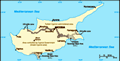
Location: Middle East, island in the Mediterranean Sea, south of Turkey
Geographic coordinates: 35 00 N, 33 00 E
Map references: Middle East
Area: Total: 9,250 sq km (of which 3,355 sq km are in north Cyprus) land: 9,240 sq km water: 10 sq km
Area - comparative: About 0.6 times the size of Connecticut
Land boundaries: Total: NA; note - boundary with Dhekelia is being resurveyed border countries: Akrotiri 47.4 km, Dhekelia NA
Coastline: 648 km
Maritime claims: Territorial sea: 12 nm continental shelf: 200-m depth or to the depth of exploitation
Climate: Temperate; Mediterranean with hot, dry summers and cool winters
Terrain: Central plain with mountains to north and south; scattered but significant plains along southern coast
Elevation extremes: Lowest point: Mediterranean Sea 0 m highest point: Mount Olympus 1,951 m
Natural resources: Copper, pyrites, asbestos, gypsum, timber, salt, marble, clay earth pigment
Land use: Arable land: 7.79% permanent crops: 4.44% other: 87.77% (2001)
Irrigated land: 382 sq km (2001 est.)
Natural hazards: Moderate earthquake activity; droughts
Environment - current issues: Water resource problems (no natural reservoir catchments, seasonal disparity in rainfall, sea water intrusion to island's largest aquifer, increased salination in the north); water pollution from sewage and industrial wastes; coastal degradation; loss of wildlife habitats from urbanization
Environment - international agreements: Party to: Air Pollution, Air Pollution-Persistent Organic Pollutants, Biodiversity, Climate Change, Climate Change-Kyoto Protocol, Desertification, Endangered Species, Environmental Modification, Hazardous Wastes, Law of the Sea, Marine Dumping, Ozone Layer Protection, Ship Pollution signed, but not ratified: none of the selected agreements
Geography - note: The third largest island in the Mediterranean Sea (after Sicily and Sardinia)
Advertisement
The information here has been derived from Public Domain Sources such as the CIA World Factbook. No liability can be taken for any inaccuracies.
Tot: 0.035s; Tpl: 0.007s; cc: 6; qc: 6; dbt: 0.007s; 1; m:domysql w:travelblog (10.17.0.13); sld: 1;
; mem: 1.1mb
 A former British colony, Cyprus received independence in 1960 following years of resistance to British rule. Tensions between the Greek Cypriot majority and Turkish Cypriot minority came to a head in December 1963, when violence broke out in the capi...