Macedonian Geography, Macedonia Geography
Advertisement
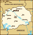
Location: Southeastern Europe, north of Greece
Geographic coordinates: 41 50 N, 22 00 E
Map references: Europe
Area: Total: 25,333 sq km land: 24,856 sq km water: 477 sq km
Area - comparative: Slightly larger than Vermont
Land boundaries: Total: 766 km border countries: Albania 151 km, Bulgaria 148 km, Greece 246 km, Serbia and Montenegro 221 km
Coastline: 0 km (landlocked)
Maritime claims: None (landlocked)
Climate: Warm, dry summers and autumns and relatively cold winters with heavy snowfall
Terrain: Mountainous territory covered with deep basins and valleys; three large lakes, each divided by a frontier line; country bisected by the Vardar River
Elevation extremes: Lowest point: Vardar River 50 m highest point: Golem Korab (Maja e Korabit) 2,764 m
Natural resources: Low-grade iron ore, copper, lead, zinc, chromite, manganese, nickel, tungsten, gold, silver, asbestos, gypsum, timber, arable land
Land use: Arable land: 22.26% permanent crops: 1.81% other: 75.93% (2001)
Irrigated land: 550 sq km (1998 est.)
Natural hazards: High seismic risks
Environment - current issues: Air pollution from metallurgical plants
Environment - international agreements: Party to: Air Pollution, Biodiversity, Climate Change, Climate Change-Kyoto Protocol, Endangered Species, Hazardous Wastes, Law of the Sea, Ozone Layer Protection, Wetlands signed, but not ratified: none of the selected agreements
Geography - note: Landlocked; major transportation corridor from Western and Central Europe to Aegean Sea and Southern Europe to Western Europe
Advertisement
The information here has been derived from Public Domain Sources such as the CIA World Factbook. No liability can be taken for any inaccuracies.
Tot: 0.019s; Tpl: 0.008s; cc: 3; qc: 2; dbt: 0.0017s; 1; m:domysql w:travelblog (10.17.0.13); sld: 1;
; mem: 1.1mb
 International recognition of Macedonia's independence from Yugoslavia in 1991 was delayed by Greece's objection to the new state's use of what it considered a Hellenic name and symbols. Greece finally lifted its trade blockade in 1995 and the two cou...