Lithuanian Geography, Lithuania Geography
Advertisement
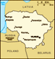
Location: Eastern Europe, bordering the Baltic Sea, between Latvia and Russia
Geographic coordinates: 56 00 N, 24 00 E
Map references: Europe
Area: Total: 65,200 sq km land: NA sq km water: NA sq km
Area - comparative: Slightly larger than West Virginia
Land boundaries: Total: 1,273 km border countries: Belarus 502 km, Latvia 453 km, Poland 91 km, Russia (Kaliningrad) 227 km
Coastline: 99 km
Maritime claims: Territorial sea: 12 nm
Climate: Transitional, between maritime and continental; wet, moderate winters and summers
Terrain: Lowland, many scattered small lakes, fertile soil
Elevation extremes: Lowest point: Baltic Sea 0 m highest point: Juozapines/Kalnas 292 m
Natural resources: Peat, arable land
Land use: Arable land: 45.22% permanent crops: 0.91% other: 53.87% (2001)
Irrigated land: 90 sq km (1998 est.)
Natural hazards: NA
Environment - current issues: Contamination of soil and groundwater with petroleum products and chemicals at military bases
Environment - international agreements: Party to: Air Pollution, Biodiversity, Climate Change, Climate Change-Kyoto Protocol, Endangered Species, Hazardous Wastes, Law of the Sea, Ozone Layer Protection, Ship Pollution, Wetlands signed, but not ratified: Air Pollution-Persistent Organic Pollutants
Geography - note: Fertile central plains are separated by hilly uplands that are ancient glacial deposits
Advertisement
The information here has been derived from Public Domain Sources such as the CIA World Factbook. No liability can be taken for any inaccuracies.
Tot: 0.046s; Tpl: 0.007s; cc: 3; qc: 8; dbt: 0.0091s; 1; m:domysql w:travelblog (10.17.0.13); sld: 1;
; mem: 1.1mb
 Independent between the two World Wars, Lithuania was annexed by the USSR in 1940. On 11 March 1990, Lithuania became the first of the Soviet republics to declare its independence, but Moscow did not recognize this proclamation until September of 199...