Croatian Geography, Croatia Geography
Advertisement
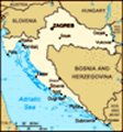
Location: Southeastern Europe, bordering the Adriatic Sea, between Bosnia and Herzegovina and Slovenia
Geographic coordinates: 45 10 N, 15 30 E
Map references: Europe
Area: Total: 56,542 sq km land: 56,414 sq km water: 128 sq km
Area - comparative: Slightly smaller than West Virginia
Land boundaries: Total: 2,197 km border countries: Bosnia and Herzegovina 932 km, Hungary 329 km, Serbia and Montenegro (north) 241 km, Serbia and Montenegro (south) 25 km, Slovenia 670 km
Coastline: 5,835 km (mainland 1,777 km, islands 4,058 km)
Maritime claims: Territorial sea: 12 nm continental shelf: 200-m depth or to the depth of exploitation
Climate: Mediterranean and continental; continental climate predominant with hot summers and cold winters; mild winters, dry summers along coast
Terrain: Geographically diverse; flat plains along Hungarian border, low mountains and highlands near Adriatic coastline and islands
Elevation extremes: Lowest point: Adriatic Sea 0 m highest point: Dinara 1,830 m
Natural resources: Oil, some coal, bauxite, low-grade iron ore, calcium, gypsum, natural asphalt, silica, mica, clays, salt, hydropower
Land use: Arable land: 26.09% permanent crops: 2.27% other: 71.65% (2001)
Irrigated land: 30 sq km (1998 est.)
Natural hazards: Destructive earthquakes
Environment - current issues: Air pollution (from metallurgical plants) and resulting acid rain is damaging the forests; coastal pollution from industrial and domestic waste; landmine removal and reconstruction of infrastructure consequent to 1992-95 civil strife
Environment - international agreements: Party to: Air Pollution, Air Pollution-Sulfur 94, Biodiversity, Climate Change, Desertification, Endangered Species, Hazardous Wastes, Law of the Sea, Marine Dumping, Ozone Layer Protection, Ship Pollution, Wetlands signed, but not ratified: Air Pollution-Persistent Organic Pollutants, Climate Change-Kyoto Protocol
Geography - note: Controls most land routes from Western Europe to Aegean Sea and Turkish Straits
Advertisement
The information here has been derived from Public Domain Sources such as the CIA World Factbook. No liability can be taken for any inaccuracies.
Tot: 0.021s; Tpl: 0.007s; cc: 3; qc: 2; dbt: 0.003s; 1; m:domysql w:travelblog (10.17.0.13); sld: 1;
; mem: 1.1mb
 The lands that today comprise Croatia were part of the Austro-Hungarian Empire until the close of World War I. In 1918, the Croats, Serbs, and Slovenes formed a kingdom known after 1929 as Yugoslavia. Following World War II, Yugoslavia became a feder...