Virgin Islander Geography, Virgin Islands Geography
Advertisement
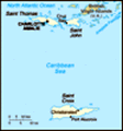
Location: Caribbean, islands between the Caribbean Sea and the North Atlantic Ocean, east of Puerto Rico
Geographic coordinates: 18 20 N, 64 50 W
Map references: Central America and the Caribbean
Area: Total: 352 sq km land: 349 sq km water: 3 sq km
Area - comparative: Twice the size of Washington, DC
Land boundaries: 0 km
Coastline: 188 km
Maritime claims: Territorial sea: 12 nm exclusive economic zone: 200 nm
Climate: Subtropical, tempered by easterly trade winds, relatively low humidity, little seasonal temperature variation; rainy season May to November
Terrain: Mostly hilly to rugged and mountainous with little level land
Elevation extremes: Lowest point: Caribbean Sea 0 m highest point: Crown Mountain 474 m
Natural resources: Sun, sand, sea, surf
Land use: Arable land: 11.76% permanent crops: 2.94% other: 85.29% (2001)
Irrigated land: NA sq km
Natural hazards: Several hurricanes in recent years; frequent and severe droughts and floods; occasional earthquakes
Environment - current issues: Lack of natural freshwater resources
Environment - international agreements:
Geography - note: Important location along the Anegada Passage - a key shipping lane for the Panama Canal; Saint Thomas has one of the best natural deepwater harbors in the Caribbean
Advertisement
The information here has been derived from Public Domain Sources such as the CIA World Factbook. No liability can be taken for any inaccuracies.
Tot: 0.044s; Tpl: 0.009s; cc: 6; qc: 6; dbt: 0.0094s; 1; m:domysql w:travelblog (10.17.0.13); sld: 1;
; mem: 1.1mb
 During the 17th century, the archipelago was divided into two territorial units, one English and the other Danish. Sugarcane, produced by slave labor, drove the islands' economy during the 18th and early 19th centuries. In 1917, the US purchased the ...