none Geography, Turks and Caicos Islands Geography
Advertisement
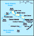
Location: Caribbean, two island groups in the North Atlantic Ocean, southeast of The Bahamas, north of Haiti
Geographic coordinates: 21 45 N, 71 35 W
Map references: Central America and the Caribbean
Area: Total: 430 sq km land: 430 sq km water: 0 sq km
Area - comparative: 2.5 times the size of Washington, DC
Land boundaries: 0 km
Coastline: 389 km
Maritime claims: Territorial sea: 12 nm exclusive fishing zone: 200 nm
Climate: Tropical; marine; moderated by trade winds; sunny and relatively dry
Terrain: Low, flat limestone; extensive marshes and mangrove swamps
Elevation extremes: Lowest point: Caribbean Sea 0 m highest point: Blue Hills 49 m
Natural resources: Spiny lobster, conch
Land use: Arable land: 2.33% permanent crops: 0% other: 97.67% (2001)
Irrigated land: NA sq km
Natural hazards: Frequent hurricanes
Environment - current issues: Limited natural fresh water resources, private cisterns collect rainwater
Environment - international agreements:
Geography - note: About 40 islands (eight inhabited)
Advertisement
The information here has been derived from Public Domain Sources such as the CIA World Factbook. No liability can be taken for any inaccuracies.
Tot: 0.031s; Tpl: 0.007s; cc: 5; qc: 8; dbt: 0.0087s; 1; m:domysql w:travelblog (10.17.0.13); sld: 1;
; mem: 1.1mb
 The islands were part of the UK's Jamaican colony until 1962, when they assumed the status of a separate crown colony upon Jamaica's independence. The governor of The Bahamas oversaw affairs from 1965 to 1973. With Bahamian independence, the islands ...