Trinidadian, Tobagonian Geography, Trinidad and Tobago Geography
Advertisement
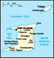
Location: Caribbean, islands between the Caribbean Sea and the North Atlantic Ocean, northeast of Venezuela
Geographic coordinates: 11 00 N, 61 00 W
Map references: Central America and the Caribbean
Area: Total: 5,128 sq km land: 5,128 sq km water: 0 sq km
Area - comparative: Slightly smaller than Delaware
Land boundaries: 0 km
Coastline: 362 km
Maritime claims: Measured from claimed archipelagic baselines territorial sea: 12 nm contiguous zone: 24 nm exclusive economic zone: 200 nm continental shelf: 200 nm or to the outer edge of the continental margin
Climate: Tropical; rainy season (June to December)
Terrain: Mostly plains with some hills and low mountains
Elevation extremes: Lowest point: Caribbean Sea 0 m highest point: El Cerro del Aripo 940 m
Natural resources: Petroleum, natural gas, asphalt
Land use: Arable land: 14.62% permanent crops: 9.16% other: 76.22% (2001)
Irrigated land: 30 sq km (1998 est.)
Natural hazards: Outside usual path of hurricanes and other tropical storms
Environment - current issues: Water pollution from agricultural chemicals, industrial wastes, and raw sewage; oil pollution of beaches; deforestation; soil erosion
Environment - international agreements: Party to: Biodiversity, Climate Change, Climate Change-Kyoto Protocol, Desertification, Endangered Species, Hazardous Wastes, Law of the Sea, Marine Life Conservation, Ozone Layer Protection, Ship Pollution, Tropical Timber 83, Tropical Timber 94, Wetlands signed, but not ratified: none of the selected agreements
Geography - note: Pitch Lake, on Trinidad's southwestern coast, is the world's largest natural reservoir of asphalt
Advertisement
The information here has been derived from Public Domain Sources such as the CIA World Factbook. No liability can be taken for any inaccuracies.
Tot: 0.035s; Tpl: 0.007s; cc: 4; qc: 8; dbt: 0.0104s; 1; m:domysql w:travelblog (10.17.0.13); sld: 1;
; mem: 1.1mb
 The islands came under British control in the 19th century; independence was granted in 1962. The country is one of the most prosperous in the Caribbean thanks largely to petroleum and natural gas production and processing. Tourism, mostly in Tobago,...