Advertisement
Published: April 16th 2011
In mid-March I found myself spending a whole day in the company of one of man’s greatest feats of engineering.
By “engineering”, I don’t simply mean “architecture” – although that’s not in any way to belittle the experience of wandering around Angkor Wat, walking along (and up and down) the Great Wall of China, imbibing the atmosphere at the Taj Mahal, or catching my breath at the first sight of the Potala Palace. By “engineering” in this context, I mean something that “operates”, with “moving bits” (to be un-technical about it).
I was embarking upon an ocean-to-ocean transit of the Panama Canal. A far cry from chasing elephants in the Namib or trekking in the Himalaya or even pottering along the Río San Juan. For once, my camera shutter clicked at things mechanical: the enormity of the lock gates, the drama of the bridges arching overhead, the volume of water pouring out below me, the vastness of passing commercial ships, the bravery of gutsy little tugs manoeuvring their huge charges into position, the size of container-port apparatus. The only form of nature to get a name-check that day was the frigate bird, effortlessly floating on thermals above the junctions
between fresh and sea water, waiting to tackle other birds feasting on the riches brought up from below.
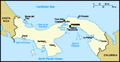
Most people will know that the Canal links the Atlantic Ocean to the Pacific Ocean and that, to do so, it slices through the fragile isthmus of Central America. And they probably assume that it goes from east to west.
Well, two out of three ain’t bad.
The Canal actually runs from northwest on the Atlantic side to southeast on the Pacific, taking advantage, in the northern section, of the then-existing route of the Chagres River. Its construction necessitated the only breach so far made in the vast mountain range that stretches from the Canadian Rockies to Patagonia, and the creation, at the time, of the largest man-made lake in the world.
The statistics are mind-blowing; the engineering obstacles and solutions incomprehensible. By way of example… an estimated 268 million cubic yards of earth were excavated in the construction of the Canal, of which 200 million were removed from the Gaillard Cut, the deepest portion of the Canal and the point at which it slices through the Continental Divide. A relatively small portion of this was used to
construct the Calzada Amador, the two-mile-long causeway which links the islands of Naos, Culebra, Perico and Flamenco to the mainland just east of the Canal’s Pacific entrance, thereby providing a massive breakwater to prevent the entrance from silting up too rapidly. There are a total of 40 pairs of lock gates, the largest being on the southern end of the Miraflores Locks where they must contend with the Pacific’s huge tidal variations: these gates measure 75 feet in height and weigh 730 tons. (All of the lock gates are 7 feet wide.) Although the Canal was completed in 1914, the lock gates have never been replaced and almost all the mechanics and logistics involved in getting a ship through the Canal are essentially unchanged from that time. It takes approximately 1 minute and 48 seconds for a pair of lock gates to open or close, and eight minutes for a lock chamber to fill or empty. Approximately 197 million gallons of fresh water are added to, or drained from, every chamber each time a ship is raised or lowered. Each chamber is identical in size: 110 feet wide, 71 feet deep and 1,000 feet long. The largest ship that can,
 Puente de las Américas
from the top of Cerro Ancón, Panama Cityat present, transit the Canal is a PANAMAX, whose dimensions allow for a clearance of only two feet either side as it is edged carefully into each lock chamber.
Even after transiting the Canal and visiting several exhibitions on the subject, I still cannot begin to understand how man created such an enormous slash across a continent, let alone finish the project two years’ ahead of schedule and under budget. Never mind the end result: the logistics involved in facilitating the construction – railways laid and moved and moved again, towns and sanitation and medical supplies created and brought in, thousands of workers enlisted and imported (without slave or PoW labour) – beggar belief.
The French began the Canal in 1880, but the death rate – thanks primarily to malaria and yellow fever (whose link to the mosquito had not then been established) – and the costs involved were so horrendous that, with the assistance of poor management and no small degree of corruption, France was nearly bankrupt by 1893. Oddly, the French – led by the brains behind the successful construction of the Suez Canal – anticipated a sea-level canal, though the enormity of the tidal drop
on the Pacific side, in contrast to that on the Atlantic side, would have meant that any resulting watercourse would have been unnavigable thanks to the appalling currents created.
It was the Americans that took the project over, although, until 1902, the route was still subject to debate. From the earliest days of European exploration of Central America, the potential and exact location for a link between the Atlantic and the Pacific Oceans had been hotly debated. Without it, the cost – in monetary, human and commercial terms – of rounding the Cape of Good Hope, was exorbitant. As commerce and ship mechanics developed, a further consideration would come to be the perishability of the goods being carried. A major canal-route contender for much of the time was in Nicaragua, using the Río San Juan heading west from the Caribbean into Lake Nicaragua, and then a man-made canal to the Pacific either through the narrow isthmus between the western side of the Lake, opposite the mouth of the Río San Juan, and the ocean, or through a slightly wider stretch of land at the foot of Volcán Momotombo at the northern end of the Lake. A canal through Panama,
monument to the man who did the impossible
Goethals monument, Panama Canal Administration Building by contrast, would seem to require more effort, more ab initio excavation given the height of the Continental Divide at that point. But the final vote in Congress – whether or not influenced by postage stamps showing the preponderance of volcanic activity in Nicaragua and circulated to Congressmen by the fabulously-named William Nelson Cromwell three days earlier – was in favour of the Panamanian route.
By this time, a link between the mosquito and the diseases which had killed so many of the French workforce had been proved, and new workers’ housing was constructed with insect screens and improved sanitation, but the enormity of the task ahead was to defeat the first two men put in charge within only a year or two of their appointment. In 1907, Theodore Roosevelt, then President of the USA, took the step of appointing a military man, Colonel George Washington Goethals, to the post of Chief Engineer. Goethals’ role in making the impossible reality is widely recognised today.
Now the Canal is a vital part of world commerce, with around 14,000 ships transiting annually (about 5% of the world’s trade). It therefore affects many of the things we eat and use and
the nautical equivalent of the bus queue
boats waiting to go through the Panama Canal see in our daily lives all round the world. In October last year, the Panama Canal Authority – fully under Panamanian control since 1999 – celebrated the one-millionth transit. In 1996, a massive expansion programme was approved by national referendum. With an estimated cost of US$5.25 billion and completion scheduled before the beginning of 2015, this project will see the Canal’s capacity double and an increase in the size of ships which can make the transit.
Such are the facts, or a reasonable smattering of them.
On a bright sunny morning, I joined three hundred of my fellow transit-ers on board The Pacific Queen in Isla Flamenco’s smart marina. With impressive efficiency, a couple of smartly-dressed ladies checked our names off a list and issued us with different coloured wrist-bands. These would determine both whether we were “partial transit-ers” or “full transit-ers” and, more immediately, when we joined the queue for breakfast and, later, lunch. (I hadn’t felt so “organised” in a very long time!) Our guide was the phenomenally knowledgeable, bilingual Gus, who, until lunchtime and our arrival at the entrance to the vast expanse of Gatun Lake, rarely seemed to pause for breath in his commentary.
Facts and figures and dates and anecdotes rolled effortlessly off his tongue, and he meandered around the boat answering all questions put to him.
As we motored out of the marina and round the point of Isla Flamenco, we could see dozens of cargo ships waiting, like a giant bus queue, to transit the Canal. Some ships have pre-booked transit times, others simply wait their turn. Although “tourist” partial transits take place two or three times a week and full transits monthly according to a pre-determined schedule, for Canal purposes, we were simply another transiting ship. Therefore, like every transiting ship, however big or small, and however experienced or otherwise, we were taken through by a Canal transit pilot who boarded The Pacific Queen from a launch on the Canal-side of the Puente de las Américas, just before we entered the main Canal waiting area. In view of our (small) size, we would be making the transit in tandem with another ship. We acquired one partner for the Pacific locks, and a second for the Atlantic locks. Our first partner would have to wait overnight in the waterway between the top of the Pedro Miguel Locks and the Galliard
one of the less technical aspects of the Canal
the wooden rowboat used by staff to throw the guiding lines aboard the transiting vessel Cut, because she no longer had time to get through the one-way-only Cut before the southbound traffic commenced later in the day; our second partner was already waiting for us at the far end of Gatun Lake, just before the Gatun Locks.
Watching the tugs manipulate our partners into the locks was extraordinary. They were helped by “mules”, small locomotives attached to railway tracks which run parallel to the locks. To get the first of the mule cables on board, a small boat rows out towards the monstrous commercial vessel, like a mosquito buzzing towards an elephant, and one of the men on board the row-boat throws a rope attached to the cable up to the deck of the ship. This looked a little basic, particularly in contrast to the engineering miracle that is the Canal, but this is how it has always been done and this is how, for the foreseeable future, it always will be done. They had experimented, Gus told us, with more technical methods, but outboard engines rusted up in the humidity of this 16-inch annual rainfall zone, and harpoon guns firing cables aboard were decreed too dangerous. So it’s still the little row-boat and
the human throw.
Once The Pacific Queen, her partner ship and the partner’s tugs were all in position, moored to the side of the lock by a loosely tied ropes, the gates, massive walls of riveted iron, gradually began to close. Although the lock gates themselves have never been replaced, hydraulic drives rather than the original manually-operated mechanics now power the gates, although this modernisation was only implemented in 1997. Once the gates were closed, we found ourselves gradually beginning to rise up the walls of the lock. Before long, the Canal staff above us were at our eye level, and then below us, as the water level rose to within only a few feet of the top of the lock. Crew on board each boat kept adjusting the mooring ropes as we ascended. Then, beyond our partner ship, we could see the further lock gates begin to open. We’d completed the first part of ascent.
Each lock has two parallel chambers, allowing for two ships or set of ships to be manoeuvred up or down the locks, independently of each other, at the same time. (Part of the expansion project is to create a third set of
locks, off to the east of the current Miraflores and Pedro Miguel Locks which, on the Pacific side, will only then intersect with the existing Canal at the top of the ascent, just before the Gaillard Cut.) In the Pedro Miguel Locks, we watched a trio of yachts lining up to start their descent to the Pacific. I had dined the previous evening with a lively Englishman who delivered yachts for a living. He had been engaged to sail a boat through the Canal from the Atlantic to the Pacific, his first Canal transit. However, it was too early in the day for any of these to have had Paul on board; but I did see him, with a couple of companion yachts, as we emerged into the Atlantic in the mid-afternoon.
By late morning, we had completed the ascent to the highest part of the Canal, 85 feet above our starting point, and entered the dramatic Gaillard Cut which severs the backbone of the Continental Divide. The Gaillard Cut is also known as the Culebra (or snake) Cut, because of the way it curves through the landscape. Its dimensions –its width and depth and bends – are the
major limiting factors in the size of the ships that can transit the Canal, and it has been subject to significant deepening and widening activities on a number of occasions during the life of the Canal. Coming towards us was the first of a pair of car-carriers. As big as a Panamax and with attendant tugs at the stern, even these behemoths were dwarfed by their surroundings. Above us arched the beautiful Puente Centenario, still visibly damaged by the appalling floods which, in December last year, had caused the Canal to be closed briefly for only the third time in its history. (The last time had been in 1989 just after the US invaded Panama in an effort to oust General Manuel Noriega; the first time had been after landslides in 1915/6.)
As we left the Cut behind, we emerged into Gatun Lake, artificially created in order to supply fresh water for the operation of the Canal, and now an attraction in its own right because the impenetrability of the surrounding rainforest has created an oasis for local flora and fauna. The Smithsonian Institute operates a research centre on Barro Colorado island, the largest created when the Chagres River
was dammed in 1913, and eco-tourism here is booming.
At this point, we disgorged our partially-transiting companions onto the wharf at Gamboa, and The Pacific Queen seemed to breathe a sigh of relief. The atmosphere on board took on an air of contented somnolence. We had had a new-experience-filled morning (not to mention an early start) and now, replete with lunch, we could dozily enjoy the sail across the turquoise waters of the Lake; Gus was taking a breather; and it would be a couple of hours before the final chapter of our voyage began.
To my mind, the Gatun Locks are the most impressive locks in the Canal. From the far side of Gatun Lake, the full 85-foot of descent back down to sea level is in front of you: you can see each of the three “steps” of the locks, like a gigantic staircase, and out to the Atlantic. As we lined up in the first lock with our new companion, we had a closer view of the delicacy of the manoeuvring process for these vast ships. While our companion was nothing like a Panamax in size overall, she was certainly not much narrower than the
lock, and there seemed to be little more than a hair’s breadth between her sides and the lock walls. On the other side of the lock, an even larger ship was being delicately shunted into position, but we were ahead of her in the process, and, as the water level on our side of the lock fell, she towered above us, dwarfing even our large companion.
Before long, we were at the final lock, watching 197 million gallons of fresh water gush out from underneath us and into the sea beyond. Such an influx of fresh water kills much of the sea-life in the area instantaneously, and the local seabird population has recognised that these end sections of the Canal are a great dining area. Gulls and frigates flocked above the gates in anticipation…
…and then the gates were opening and we were leaving the Canal and the feeding birds behind us. We began the final leg of our journey, motoring up the Chagres estuary towards the Atlantic and the city of Colón. There we would disembark for the infinitely less scenic drive back to Panama City through the falling dusk. Out to sea ahead of us yet
the Other Side
aka the Atlantic Ocean more ships were gathered, waiting their turn to transit this extraordinary waterway and keep the world of global commerce in motion.
Advertisement
Tot: 0.084s; Tpl: 0.019s; cc: 11; qc: 25; dbt: 0.0512s; 1; m:domysql w:travelblog (10.17.0.13); sld: 1;
; mem: 1.2mb


Paul Moody
non-member comment
Magic day
I was there too that day, but in a small sail boat transiting from the carribean to the Pacific. Liz took some great pictures of us pensivly approaching the first set of locks. Its really daunting for a small vessel entering the cathedral size concrete box and having millions of bathtubs flowing up underneath the boat as the locks fill up. Once through the first set of gates we motored into the inland lakes and moored up for the night with the rain forest full of frog noises and fireflies surrounding us. The next morning we had a change of pilots (every boat has one for the passage)and spent most of the day criusing past amazing uninhabited island full of howling monkeys southbound to the next set of huge locks that take us out into the great Pacific ocean where the boat was to continue to New Zealand. yup! amazing experiance, they call it the eighth wonder of the world, certainly beats going around the gale ridden cape horn as they had to in sal boats of old. I really enjoyed your descriptive blog Liz. Keep it up.