Nicaraguan Geography, Nicaragua Geography
Advertisement
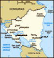
Location: Central America, bordering both the Caribbean Sea and the North Pacific Ocean, between Costa Rica and Honduras
Geographic coordinates: 13 00 N, 85 00 W
Map references: Central America and the Caribbean
Area: Total: 129,494 sq km land: 120,254 sq km water: 9,240 sq km
Area - comparative: Slightly smaller than the state of New York
Land boundaries: Total: 1,231 km border countries: Costa Rica 309 km, Honduras 922 km
Coastline: 910 km
Maritime claims: Territorial sea: 200 nm continental shelf: natural prolongation
Climate: Tropical in lowlands, cooler in highlands
Terrain: Extensive Atlantic coastal plains rising to central interior mountains; narrow Pacific coastal plain interrupted by volcanoes
Elevation extremes: Lowest point: Pacific Ocean 0 m highest point: Mogoton 2,438 m
Natural resources: Gold, silver, copper, tungsten, lead, zinc, timber, fish
Land use: Arable land: 15.94% permanent crops: 1.94% other: 82.12% (2001)
Irrigated land: 880 sq km (1998 est.)
Natural hazards: Destructive earthquakes, volcanoes, landslides; extremely susceptible to hurricanes
Environment - current issues: Deforestation; soil erosion; water pollution
Environment - international agreements: Party to: Biodiversity, Climate Change, Climate Change-Kyoto Protocol, Desertification, Endangered Species, Hazardous Wastes, Law of the Sea, Ozone Layer Protection, Ship Pollution, Wetlands signed, but not ratified: Environmental Modification
Geography - note: Largest country in Central America; contains the largest freshwater body in Central America, Lago de Nicaragua
Advertisement
The information here has been derived from Public Domain Sources such as the CIA World Factbook. No liability can be taken for any inaccuracies.
Tot: 0.085s; Tpl: 0.008s; cc: 5; qc: 8; dbt: 0.0184s; 1; m:domysql w:travelblog (10.17.0.13); sld: 1;
; mem: 1.1mb
 The Pacific Coast of Nicaragua was settled as a Spanish colony from Panama in the early 16th century. Independence from Spain was declared in 1821 and the country became an independent republic in 1838. Britain occupied the Caribbean Coast in the fir...