Guatemalan Geography, Guatemala Geography
Advertisement
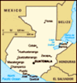
Location: Central America, bordering the North Pacific Ocean, between El Salvador and Mexico, and bordering the Gulf of Honduras (Caribbean Sea) between Honduras and Belize
Geographic coordinates: 15 30 N, 90 15 W
Map references: Central America and the Caribbean
Area: Total: 108,890 sq km land: 108,430 sq km water: 460 sq km
Area - comparative: Slightly smaller than Tennessee
Land boundaries: Total: 1,687 km border countries: Belize 266 km, El Salvador 203 km, Honduras 256 km, Mexico 962 km
Coastline: 400 km
Maritime claims: Territorial sea: 12 nm exclusive economic zone: 200 nm continental shelf: 200-m depth or to the depth of exploitation
Climate: Tropical; hot, humid in lowlands; cooler in highlands
Terrain: Mostly mountains with narrow coastal plains and rolling limestone plateau (Peten)
Elevation extremes: Lowest point: Pacific Ocean 0 m highest point: Volcan Tajumulco 4,211 m
Natural resources: Petroleum, nickel, rare woods, fish, chicle, hydropower
Land use: Arable land: 12.54% permanent crops: 5.03% other: 82.43% (2001)
Irrigated land: 1,250 sq km (1998 est.)
Natural hazards: Numerous volcanoes in mountains, with occasional violent earthquakes; Caribbean coast extremely susceptible to hurricanes and other tropical storms
Environment - current issues: Deforestation in the Peten rainforest; soil erosion; water pollution
Environment - international agreements: Party to: Antarctic Treaty, Biodiversity, Climate Change, Climate Change-Kyoto Protocol, Desertification, Endangered Species, Environmental Modification, Hazardous Wastes, Law of the Sea, Marine Dumping, Ozone Layer Protection, Ship Pollution, Wetlands signed, but not ratified: none of the selected agreements
Geography - note: No natural harbors on west coast
Advertisement
The information here has been derived from Public Domain Sources such as the CIA World Factbook. No liability can be taken for any inaccuracies.
Tot: 0.097s; Tpl: 0.007s; cc: 6; qc: 6; dbt: 0.0085s; 1; m:domysql w:travelblog (10.17.0.13); sld: 1;
; mem: 1.1mb
 The Maya civilization flourished in Guatemala and surrounding regions during the first millennium A.D. After almost three centuries as a Spanish colony, Guatemala won its independence in 1821. During the second half of the 20th century, it experience...