British Virgin Islander Geography, British Virgin Islands Geography
Advertisement
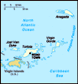
Location: Caribbean, between the Caribbean Sea and the North Atlantic Ocean, east of Puerto Rico
Geographic coordinates: 18 30 N, 64 30 W
Map references: Central America and the Caribbean
Area: Total: 153 sq km land: 153 sq km water: 0 sq km note: comprised of 16 inhabited and more than 20 uninhabited islands; includes the island of Anegada
Area - comparative: About 0.9 times the size of Washington, DC
Land boundaries: 0 km
Coastline: 80 km
Maritime claims: Territorial sea: 3 nm exclusive fishing zone: 200 nm
Climate: Subtropical; humid; temperatures moderated by trade winds
Terrain: Coral islands relatively flat; volcanic islands steep, hilly
Elevation extremes: Lowest point: Caribbean Sea 0 m highest point: Mount Sage 521 m
Natural resources: NEGL
Land use: Arable land: 20% permanent crops: 6.67% other: 73.33% (2001)
Irrigated land: NA
Natural hazards: Hurricanes and tropical storms (July to October)
Environment - current issues: Limited natural fresh water resources (except for a few seasonal streams and springs on Tortola, most of the islands' water supply comes from wells and rainwater catchments)
Environment - international agreements:
Geography - note: Strong ties to nearby US Virgin Islands and Puerto Rico
Advertisement
The information here has been derived from Public Domain Sources such as the CIA World Factbook. No liability can be taken for any inaccuracies.
Tot: 0.03s; Tpl: 0.007s; cc: 6; qc: 6; dbt: 0.0063s; 1; m:domysql w:travelblog (10.17.0.13); sld: 1;
; mem: 1.1mb
 First settled by the Dutch in 1648, the islands were annexed in 1672 by the English. The economy is closely tied to the larger and more populous US Virgin Islands to the west; the US dollar is the legal currency....