Sahrawi,Sahrawian, Sahraouian Geography, Western Sahara Geography
Advertisement
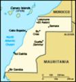
Location: Northern Africa, bordering the North Atlantic Ocean, between Mauritania and Morocco
Geographic coordinates: 24 30 N, 13 00 W
Map references: Africa
Area: Total: 266,000 sq km land: 266,000 sq km water: 0 sq km
Area - comparative: About the size of Colorado
Land boundaries: Total: 2,046 km border countries: Algeria 42 km, Mauritania 1,561 km, Morocco 443 km
Coastline: 1,110 km
Maritime claims: Contingent upon resolution of sovereignty issue
Climate: Hot, dry desert; rain is rare; cold offshore air currents produce fog and heavy dew
Terrain: Mostly low, flat desert with large areas of rocky or sandy surfaces rising to small mountains in south and northeast
Elevation extremes: Lowest point: Sebjet Tah -55 m highest point: unnamed location 463 m
Natural resources: Phosphates, iron ore
Land use: Arable land: 0.02% permanent crops: 0% other: 99.98% (2001)
Irrigated land: NA sq km
Natural hazards: Hot, dry, dust/sand-laden sirocco wind can occur during winter and spring; widespread harmattan haze exists 60% of time, often severely restricting visibility
Environment - current issues: Sparse water and lack of arable land
Environment - international agreements: Party to: none of the selected agreements signed, but not ratified: none of the selected agreements
Geography - note: The waters off the coast are particularly rich fishing areas
Advertisement
The information here has been derived from Public Domain Sources such as the CIA World Factbook. No liability can be taken for any inaccuracies.
Tot: 0.035s; Tpl: 0.007s; cc: 3; qc: 10; dbt: 0.0115s; 1; m:domysql w:travelblog (10.17.0.13); sld: 1;
; mem: 1.1mb
 Morocco virtually annexed the northern two-thirds of Western Sahara (formerly Spanish Sahara) in 1976, and the rest of the territory in 1979, following Mauritania's withdrawal. A guerrilla war with the Polisario Front contesting Rabat's sovereignty e...