Tunisian Geography, Tunisia Geography
Advertisement
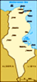
Location: Northern Africa, bordering the Mediterranean Sea, between Algeria and Libya
Geographic coordinates: 34 00 N, 9 00 E
Map references: Africa
Area: Total: 163,610 sq km land: 155,360 sq km water: 8,250 sq km
Area - comparative: Slightly larger than Georgia
Land boundaries: Total: 1,424 km border countries: Algeria 965 km, Libya 459 km
Coastline: 1,148 km
Maritime claims: Territorial sea: 12 nm contiguous zone: 24 nm
Climate: Temperate in north with mild, rainy winters and hot, dry summers; desert in south
Terrain: Mountains in north; hot, dry central plain; semiarid south merges into the Sahara
Elevation extremes: Lowest point: Shatt al Gharsah -17 m highest point: Jebel ech Chambi 1,544 m
Natural resources: Petroleum, phosphates, iron ore, lead, zinc, salt
Land use: Arable land: 17.86% permanent crops: 13.74% other: 68.4% (2001)
Irrigated land: 3,800 sq km (1998 est.)
Natural hazards: NA
Environment - current issues: Toxic and hazardous waste disposal is ineffective and poses health risks; water pollution from raw sewage; limited natural fresh water resources; deforestation; overgrazing; soil erosion; desertification
Environment - international agreements: Party to: Biodiversity, Climate Change, Climate Change-Kyoto Protocol, Desertification, Endangered Species, Environmental Modification, Hazardous Wastes, Law of the Sea, Marine Dumping, Ozone Layer Protection, Ship Pollution, Wetlands signed, but not ratified: Marine Life Conservation
Geography - note: Strategic location in central Mediterranean; Malta and Tunisia are discussing the commercial exploitation of the continental shelf between their countries, particularly for oil exploration
Advertisement
The information here has been derived from Public Domain Sources such as the CIA World Factbook. No liability can be taken for any inaccuracies.
Tot: 0.043s; Tpl: 0.011s; cc: 6; qc: 6; dbt: 0.0073s; 1; m:domysql w:travelblog (10.17.0.13); sld: 1;
; mem: 1.1mb
 Following independence from France in 1956, President Habib BOURGUIBA established a strict one-party state. He dominated the country for 31 years, repressing Islamic fundamentalism and establishing rights for women unmatched by any other Arab nation....