Nigerian Geography, Nigeria Geography
Advertisement
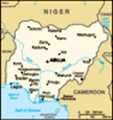
Location: Western Africa, bordering the Gulf of Guinea, between Benin and Cameroon
Geographic coordinates: 10 00 N, 8 00 E
Map references: Africa
Area: Total: 923,768 sq km land: 910,768 sq km water: 13,000 sq km
Area - comparative: Slightly more than twice the size of California
Land boundaries: Total: 4,047 km border countries: Benin 773 km, Cameroon 1,690 km, Chad 87 km, Niger 1,497 km
Coastline: 853 km
Maritime claims: Territorial sea: 12 nm exclusive economic zone: 200 nm continental shelf: 200-m depth or to the depth of exploitation
Climate: Varies; equatorial in south, tropical in center, arid in north
Terrain: Southern lowlands merge into central hills and plateaus; mountains in southeast, plains in north
Elevation extremes: Lowest point: Atlantic Ocean 0 m highest point: Chappal Waddi 2,419 m
Natural resources: Natural gas, petroleum, tin, iron ore, coal, limestone, niobium, lead, zinc, arable land
Land use: Arable land: 31.29% permanent crops: 2.96% other: 65.75% (2001)
Irrigated land: 2,330 sq km (1998 est.)
Natural hazards: Periodic droughts; flooding
Environment - current issues: Soil degradation; rapid deforestation; urban air and water pollution; desertification; oil pollution - water, air, and soil; has suffered serious damage from oil spills; loss of arable land; rapid urbanization
Environment - international agreements: Party to: Biodiversity, Climate Change, Climate Change-Kyoto Protocol, Desertification, Endangered Species, Hazardous Wastes, Law of the Sea, Marine Dumping, Marine Life Conservation, Ozone Layer Protection, Wetlands signed, but not ratified: none of the selected agreements
Geography - note: The Niger enters the country in the northwest and flows southward through tropical rain forests and swamps to its delta in the Gulf of Guinea
Advertisement
The information here has been derived from Public Domain Sources such as the CIA World Factbook. No liability can be taken for any inaccuracies.
Tot: 0.036s; Tpl: 0.007s; cc: 3; qc: 2; dbt: 0.0036s; 1; m:domysql w:travelblog (10.17.0.13); sld: 1;
; mem: 1.1mb
 Following nearly 16 years of military rule, a new constitution was adopted in 1999, and a peaceful transition to civilian government was completed. The president faces the daunting task of rebuilding a petroleum-based economy, whose revenues have bee...