Nigerien Geography, Niger Geography
Advertisement
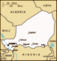
Location: Western Africa, southeast of Algeria
Geographic coordinates: 16 00 N, 8 00 E
Map references: Africa
Area: Total: 1.267 million sq km land: 1,266,700 sq km water: 300 sq km
Area - comparative: Slightly less than twice the size of Texas
Land boundaries: Total: 5,697 km border countries: Algeria 956 km, Benin 266 km, Burkina Faso 628 km, Chad 1,175 km, Libya 354 km, Mali 821 km, Nigeria 1,497 km
Coastline: 0 km (landlocked)
Maritime claims: None (landlocked)
Climate: Desert; mostly hot, dry, dusty; tropical in extreme south
Terrain: Predominately desert plains and sand dunes; flat to rolling plains in south; hills in north
Elevation extremes: Lowest point: Niger River 200 m highest point: Mont Bagzane 2,022 m
Natural resources: Uranium, coal, iron ore, tin, phosphates, gold, molybdenum, gypsum, salt, petroleum
Land use: Arable land: 3.54% permanent crops: 0.01% other: 96.45% (2001)
Irrigated land: 660 sq km (1998 est.)
Natural hazards: Recurring droughts
Environment - current issues: Overgrazing; soil erosion; deforestation; desertification; wildlife populations (such as elephant, hippopotamus, giraffe, and lion) threatened because of poaching and habitat destruction
Environment - international agreements: Party to: Biodiversity, Climate Change, Climate Change-Kyoto Protocol, Desertification, Endangered Species, Environmental Modification, Hazardous Wastes, Ozone Layer Protection, Wetlands signed, but not ratified: Law of the Sea
Geography - note: Landlocked; one of the hottest countries in the world: northern four-fifths is desert, southern one-fifth is savanna, suitable for livestock and limited agriculture
Advertisement
The information here has been derived from Public Domain Sources such as the CIA World Factbook. No liability can be taken for any inaccuracies.
Tot: 0.036s; Tpl: 0.007s; cc: 3; qc: 10; dbt: 0.012s; 1; m:domysql w:travelblog (10.17.0.13); sld: 1;
; mem: 1.1mb
 Not until 1993, 33 years after independence from France, did Niger hold its first free and open elections. A 1995 peace accord ended a five-year Tuareg insurgency in the north. Coups in 1996 and 1999 were followed by the creation of a National Reconc...