Guinean Geography, Guinea-Bissau Geography
Advertisement
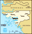
Location: Western Africa, bordering the North Atlantic Ocean, between Guinea and Senegal
Geographic coordinates: 12 00 N, 15 00 W
Map references: Africa
Area: Total: 36,120 sq km land: 28,000 sq km water: 8,120 sq km
Area - comparative: Slightly less than three times the size of Connecticut
Land boundaries: Total: 724 km border countries: Guinea 386 km, Senegal 338 km
Coastline: 350 km
Maritime claims: Territorial sea: 12 nm exclusive economic zone: 200 nm
Climate: Tropical; generally hot and humid; monsoonal-type rainy season (June to November) with southwesterly winds; dry season (December to May) with northeasterly harmattan winds
Terrain: Mostly low coastal plain rising to savanna in east
Elevation extremes: Lowest point: Atlantic Ocean 0 m highest point: unnamed location in the northeast corner of the country 300 m
Natural resources: Fish, timber, phosphates, bauxite, clay, granite, limestone, unexploited deposits of petroleum
Land use: Arable land: 10.67% permanent crops: 8.82% other: 80.51% (2001)
Irrigated land: 170 sq km (1998 est.)
Natural hazards: Hot, dry, dusty harmattan haze may reduce visibility during dry season; brush fires
Environment - current issues: Deforestation; soil erosion; overgrazing; overfishing
Environment - international agreements: Party to: Biodiversity, Climate Change, Desertification, Endangered Species, Law of the Sea, Wetlands signed, but not ratified: none of the selected agreements
Geography - note: This small country is swampy along its western coast and low-lying further inland
Advertisement
The information here has been derived from Public Domain Sources such as the CIA World Factbook. No liability can be taken for any inaccuracies.
Tot: 0.035s; Tpl: 0.007s; cc: 3; qc: 8; dbt: 0.0102s; 1; m:domysql w:travelblog (10.17.0.13); sld: 1;
; mem: 1.1mb
 Since independence from Portugal in 1974, Guinea-Bissau has experienced considerable upheaval. The founding government consisted of a single party system and command economy. In 1980, a military coup established Joao VIEIRA as president and a path to...