Burkinabe Geography, Burkina Faso Geography
Advertisement
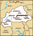
Location: Western Africa, north of Ghana
Geographic coordinates: 13 00 N, 2 00 W
Map references: Africa
Area: Total: 274,200 sq km land: 273,800 sq km water: 400 sq km
Area - comparative: Slightly larger than Colorado
Land boundaries: Total: 3,193 km border countries: Benin 306 km, Cote d'Ivoire 584 km, Ghana 549 km, Mali 1,000 km, Niger 628 km, Togo 126 km
Coastline: 0 km (landlocked)
Maritime claims: None (landlocked)
Climate: Tropical; warm, dry winters; hot, wet summers
Terrain: Mostly flat to dissected, undulating plains; hills in west and southeast
Elevation extremes: Lowest point: Mouhoun (Black Volta) River 200 m highest point: Tena Kourou 749 m
Natural resources: Manganese, limestone, marble; small deposits of gold, phosphates, pumice, salt
Land use: Arable land: 14.43% permanent crops: 0.19% other: 85.38% (2001)
Irrigated land: 250 sq km (1998 est.)
Natural hazards: Recurring droughts
Environment - current issues: Recent droughts and desertification severely affecting agricultural activities, population distribution, and the economy; overgrazing; soil degradation; deforestation
Environment - international agreements: Party to: Biodiversity, Climate Change, Desertification, Endangered Species, Hazardous Wastes, Law of the Sea, Marine Life Conservation, Ozone Layer Protection, Wetlands signed, but not ratified: none of the selected agreements
Geography - note: Landlocked savanna cut by the three principal rivers of the Black, Red, and White Voltas
Advertisement
The information here has been derived from Public Domain Sources such as the CIA World Factbook. No liability can be taken for any inaccuracies.
Tot: 0.031s; Tpl: 0.008s; cc: 6; qc: 6; dbt: 0.0066s; 1; m:domysql w:travelblog (10.17.0.13); sld: 1;
; mem: 1.1mb
 Burkina Faso (formerly Upper Volta) achieved independence from France in 1960. Repeated military coups during the 1970s and 1980s were followed by multiparty elections in the early 1990s. Burkina Faso's high population density and limited natural res...